2022 Tropical Season thread MERGE (2 Viewers)

If that scenario holds true, they will probably need to rebuild the access highway to get back there.
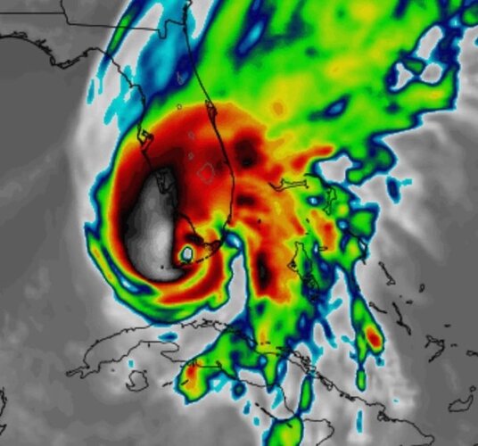
And if it goes Cat 5 on south Florida things could be ugly there for a while. :cry:
The barracks I stayed at while stationed at Key West was 1 foot above sea level. When Georges hit, we evacuated but I was one of the first allowed back in because I was the NWPL custodian. The roof of a building that housed a lot of classified material was torn off and there was classified stuff scattered all over the place, the runways, the mangroves, just a total mess. It took us a week or more to gather up what we could, and we still couldn't tell what was missing vs what was destroyed.
 
Lindner:

New tropical depression forms in the southern Caribbean Sea

Significant hurricane threat to FL in 5-6 days.

Discussion:

98L has closed off a well defined low level center in the last 24 hours which has shown up in both radar data from Curacao and USAF missions. Last evening a deep ball of convection developed on the southwest side of the low level circulation and this convection has continued through the night. NE wind shear continues over TD 9, but is starting to weaken as Fiona moves northward toward Atlantic Canada. Current intensity is set at 30kts with NOAA buoy 42059 reporting winds of 27kts overnight.

Track:
TD 9 is moving WNW and a bend back toward the west is likely today into early Sunday as a thin ridge builds north of #9 with Fiona departing to the N. Additionally, NE/E upper level shear will continue to displace the convective activity to the west and southwest of the low level center and help “tug” the center in that direction. By Sunday, as TD 9 reaches the western Caribbean south of Jamaica, the ridge to the north will begin to decay and the system will approach a deep layer trough along the US east coast and begin to turn NW and N near the Cayman Islands. How sharp this northward turn transpires remains in some question. Guiding this turn will be the intensity of the system in the western Caribbean Sea and the depth of the trough along the US east coast.

The GFS has shifted significantly eastward and now aligns with the CMC and ICON guidance while the ECWMF is even further east showing a track across Cuba and extreme southern FL/Keys. The multi-model consensus has shifted east some in the last 24 hours. The current NHC forecast track in near the multi-model consensus down the center of the guidance cluster.

Based on this forecast a significant hurricane will be approaching the western coast of FL in 5-6 days. Due to the shape of the SW/W FL coast and the angle from which the hurricane will be approaching (south or southwest) very small deviations in the track can have large differences on impacts at particular locations.

Intensity:
TD 9 will continue to experience moderate NE winds shear for the next 24-36 hours which will prevent significant intensification. After 36 hours, the NE wind shear will abate and the tropical system will be located over extremely deep warm waters of the western Caribbean Sea and in an upper level environment increasingly favorable for development. Once a defined inner core is formed, significant intensification is likely…how long this takes to happen will likely determine how strong the system becomes before reaching Cuba and the extreme southeast Gulf of Mexico. While land interaction with Cuba could briefly disrupt the inner core of the system, rapidly intensifying hurricanes crossing Cuba from south to north tend to maintain their structure well and in the past shown little weakening.

NHC is capping the intensity prior to landfall in Cuba and over the SE Gulf at 110mph (just below major hurricane intensity), but this is generally below the model consensus and upward adjustments in the intensity forecast may be needed. Several models make this a category 4 hurricane in the NW Caribbean into the Gulf of Mexico.
 
The latest from Wxman57.

Those 35-40kt SFMR all look suspect. Organization barely qualifies as a depression this morning (naked swirl moving away from the convection), but the NHC wanted to start advisories today. This isn't a TS. It's a poorly-organized depression, if that. Wait for the shear to drop off tomorrow afternoon. Back to my advisory. Striking near Ft. Myers Tuesday night as an 85kt hurricane (Cat 2). Watch out Carolinas, it may be stronger once it passes Florida.

He followed up with this.


you will definitely be fine in Lafite. Strong west to east jet stream across the northern Gulf won't let it come to Louisiana.
 
Last edited:
The latest from Wxman57.

Those 35-40kt SFMR all look suspect. Organization barely qualifies as a depression this morning (naked swirl moving away from the convection), but the NHC wanted to start advisories today. This isn't a TS. It's a poorly-organized depression, if that. Wait for the shear to drop off tomorrow afternoon. Back to my advisory. Striking near Ft. Myers Tuesday night as an 85kt hurricane (Cat 2). Watch out Carolinas, it may be stronger once it passes Florida.

He followed up with this.


you will definitely be fine in Lafite. Strong west to east jet stream across the northern Gulf won't let it come to Louisiana.
Cautiously optimistic for NOLA, but not letting my guard down on this one.
 
The latest from Wxman57.

Those 35-40kt SFMR all look suspect. Organization barely qualifies as a depression this morning (naked swirl moving away from the convection), but the NHC wanted to start advisories today. This isn't a TS. It's a poorly-organized depression, if that. Wait for the shear to drop off tomorrow afternoon. Back to my advisory. Striking near Ft. Myers Tuesday night as an 85kt hurricane (Cat 2). Watch out Carolinas, it may be stronger once it passes Florida.

He followed up with this.


you will definitely be fine in Lafite. Strong west to east jet stream across the northern Gulf won't let it come to Louisiana.

Yeah, the possible track and impact on Carolinas has my interest for sure. Interesting that it could be stronger after Florida - I suppose he’s referring to possible entry into the Atlantic? Strengthening over land is rare, correct?
 
Cautiously optimistic for NOLA, but not letting my guard down on this one.
Will never forget that 250-mile shift westward in the Katrina track 70-something hours out from landfall. Thursday afternoon, 8/25/2005 leaving work -- "Katrina's going to slam Destin, New Orleans is going to dodge it." Six hours later, 10 p.m. news that same night -- "Katrina's making a beeline for New Orleans! And this track is locked in!"

Though I take it that's far less likely with today's tracking technology.
Plus a front coming in should keep it East.
 
Yeah, the possible track and impact on Carolinas has my interest for sure. Interesting that it could be stronger after Florida - I suppose he’s referring to possible entry into the Atlantic? Strengthening over land is rare, correct?
Yeah I think he means it crossing Florida, then getting over the Gulf Stream and increasing.
 

Create an account or login to comment

You must be a member in order to leave a comment

Create account

Create an account on our community. It's easy!

Log in

Already have an account? Log in here.

Users who are viewing this thread

    Back
    Top Bottom