Hurricane Season 2021 (1 Viewer)

Not much there really, two coming off Africa are going to be fish storms and the one off Mexico looks to be hugging land along the way to really get developed. The one in the western Atlantic may pose some problems for the central East Coast.
Too early to rule out the one in the gulf becoming a problem. Weak steering currents as it is making landfall always makes me a little nervous. Reminds me a lot of Tropical Storm Imelda. Same time of the year too. I doubt it gets real strong but doesn't mean it won't cause some problems. Also a shift East could keep it over water a lot longer.
 
Too early to rule out the one in the gulf becoming a problem. Weak steering currents as it is making landfall always makes me a little nervous. Reminds me a lot of Tropical Storm Imelda. Same time of the year too. I doubt it gets real strong but doesn't mean it won't cause some problems. Also a shift East could keep it over water a lot longer.
Clemms, these sort of storms aren't in much larger, more expansive bodies of water like the Atlantic or the Caribbean, where they can assiduously take their sweet time forming, or slowly, gradually gain strength before deciding whether their going to hit first---Cuba, Puerto Rico, variety of several Central American countries, or Yucatan Peninsula or Belize, if an active tropical system develops into a TS once its in GOM, weak steering currents aren't that pertinent of a serious factor for people watching them developing living from Florida to Texas because it can't bump-fork around for 3-4 days, meandering around like a pesky flea gradually turning into a Cat 3 storm some Weather Channel meteorlogists privately wish it does, safely from their offices in Atlanta (Hey, Jim Cantore). In the GOM, if a TS is moving even at 5-10 mph, its going to hit somewhere in 1-2 days, max. The GOM is one of those bodies of water where its actually 3-4x less the size of the Mediterranean, a lot warmer, its the worlds largest salt body of water, but any emerging system ether sheets or gets off the pot in terms of its overall, eventual development because its smaller, enclosed geographic size doesn't permit any invests having two weeks or maybe 4-5 days to form and develop like the Atlantic and Caribbean allow, respectively.
 
Clemms, these sort of storms aren't in much larger, more expansive bodies of water like the Atlantic or the Caribbean, where they can assiduously take their sweet time forming, or slowly, gradually gain strength before deciding whether their going to hit first---Cuba, Puerto Rico, variety of several Central American countries, or Yucatan Peninsula or Belize, if an active tropical system develops into a TS once its in GOM, weak steering currents aren't that pertinent of a serious factor for people watching them developing living from Florida to Texas because it can't bump-fork around for 3-4 days, meandering around like a pesky flea gradually turning into a Cat 3 storm some Weather Channel meteorlogists privately wish it does, safely from their offices in Atlanta (Hey, Jim Cantore). In the GOM, if a TS is moving even at 5-10 mph, its going to hit somewhere in 1-2 days, max. The GOM is one of those bodies of water where its actually 3-4x less the size of the Mediterranean, a lot warmer, its the worlds largest salt body of water, but any emerging system ether sheets or gets off the pot in terms of its overall, eventual development because its smaller, enclosed geographic size doesn't permit any invests having two weeks or maybe 4-5 days to form and develop like the Atlantic and Caribbean allow, respectively.
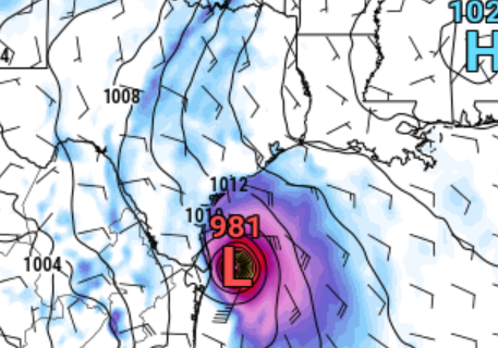
Weak steering currents are exactly the situation in which it can sit off the coast for 3-4 days. The latest GFS has the center of circulation sitting just off the Galveston coast Tuesday morning and just north of Lake Charles still on Friday as a weak remnant low.

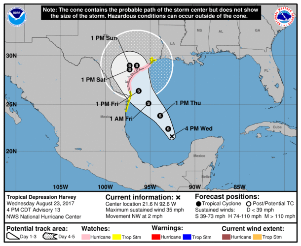
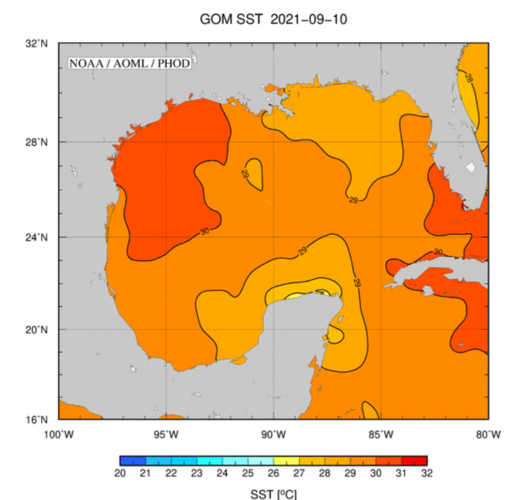
As for storms forming in this area, it's very near the location as Hurricane Harvey when it started out with a somewhat similar large scale pattern. Tropical Storm Imelda didn't even get a name until it was almost on land and it proceeded to dump over 40" of rain and flooded the hell out of SE Tx after stalling just inland. Neither storm were considered a particularly big threat 3 days out and this system is working with even warmer water than Ida did.

How about a system that stalled just onshore in La in 2016 that wasn't even strong enough to be a depression? Ask Livingston Parish how that turned out.

I'm not saying this one will be anything like those three. Just saying it's too early to discount it. That area of the gulf with steering currents breaking down at landfall have resulted in some of the costliest disasters in US history and right now we have models showing the storm developing into a high end TS to as high as a cat 2 hurricane and stalling right at landfall. It should be watched carefully for an area of the country that has seen one disaster after another the last 5 years.

My best guess at the moment is a minimal impact tropical system that struggles with shear as it approaches land and the feeder band that sets up farther to the East struggles to stay mature due to shear and westerly mid levels but it's not far from being a situation where someone gets feet of rain.

The 00z GFS for reference. Not a situation you ignore. Just a few small changes in variables and you could have anything from a major hurricane headed right at the 5th largest metro in the country or yet another major flooding event. If you are looking at model trends, it is even more reason for concern, not a reason to ignore it.
1631420920585.png

Here is the forecast path for Tropical Storm Harvey less than 3 days before landfall.
1631421191894.png

Gulf of Mx current water temps.
1631421783709.png
 
Last edited:
From Lindner:

94L (Sun AM)

Heavy rainfall event likely Mon-Wed over coastal SE TX.

Tropical system likely to form over western Gulf later today or Monday.


Much talked about tropical wave axis has moved over the Bay of Campeche this morning with a slight increase in convection. Numerous showers and thunderstorms extend across the southern and central Gulf of Mexico in association with 94L and a trough axis that is moving WNW/NW over the NW Gulf. A significant surge in tropical moisture is over the NW Gulf of Mexico and will begin to move inland today. Rain chances will increase later this morning from the coast inland as this tropical moisture approaches from the SE.

Tropical moisture will be in place late today and with the trough axis in the region and increasing low level convergence early Monday, expect widespread rains to develop near the coast and offshore well to the north and northeast of the developing tropical system. Main threat appears to be right along the coast and maybe extending inland to the first row of inland counties for early Monday. Hourly rainfall rates could be high during this time with 2-3 inches possible which would lead to some flooding in more urban areas.

Monday PM-Tuesday:
Tropical storm likely to move northward and into SE TX or across our coastal waters during this period. 94L will likely develop a closed low level circulation later today or Monday and move northward right along the eastern MX and S TX coast and then NNE toward Matagorda Bay Monday night. This places most of SE TX on the “dirty” side of the system with onshore winds and bands of heavy rainfall. The GFS continues to show the system turning harder to the NE and ENE across the upper TX coast and stays offshore and this remains a possibility although the majority of the guidance cluster and ensembles bring the system just inland over Matagorda Bay or Matagorda County and then continue toward the NNE of NE across SE TX and exit the area on Wednesday.

Since a low level center has yet to form there remains some uncertainty in the exact track of the system and that will have implications on the forecast impacts over the area.

Impacts:

Rainfall:

Heavy rains will begin along the coast later today and especially into Monday with the trough axis moving slightly inland. How far this trough axis moves inland will determine how far the heavy rains advance on Monday. Certainly the coastal counties (Chambers, Galveston, Brazoria, Matagorda, and Jackson) look to see heavy rainfall, but this could extend inland into southern Liberty, southern Harris, Fort Bend, and Wharton counties also. These types of setups tend to favor the coastal areas or coastal waters for the greatest rainfall amounts with a sharp gradient to the NW. Tropical system will then move into the area from the SW late Monday into Tuesday with additional heavy rains…likely again favoring the coastal areas.

Coastal Counties: widespread 5-8 inches (iso 10-15 inches)
South of I-10: widespread 3-6 inches (iso 8-12 inches)
North of I-10: widespread 2-4 inches (iso 6 inches)

Given the tropical moisture in place hourly rainfall rates of 2-4 inches will be possible under the stronger cells which will lead to quick accumulations. While grounds are dry initially, waves of rainfall will gradually saturate the soils leading the increasing run-off. Flooding will be possible, especially across the coastal counties and areas south of I-10 where the greatest rainfall is most likely at the moment.

Tides/Seas:
Tides are starting to increase this morning with the increasing easterly flow and both tides and seas will increase into Monday and Tuesday. Seas will build 6-12 ft across the coastal waters and these higher swells will result in wave run-up along the coast starting later today. Tropical storm approaches from the SW late Monday and seas may build into a solid 9-12 ft range. Additionally onshore push from wind will drive some storm surge toward the coast. Current thinking is total water levels of 3.5-4.0 feet above MLLW (barnacle level), but a slightly stronger tropical system could push these values toward 4.5-5.5ft. Minor coastal flooding is likely at times of high tide in the 3.5-4.0 ft range and more widespread lowland coastal flooding would be possible at levels over 5.0ft (similar to Beta last year).

Think 3.5-4.0ft is the most likely levels, but reasonable worst case potential is 5.0-5.5 ft which would cause flooding in and around Clear Lake, Seabrook, Shoreacres, west end of Galveston, Bolivar, and Surfside areas.

Winds:
Currently going with 20-25kts along the coast starting on Monday and may build up into tropical storm sustained Monday night and Tuesday as tropical system comes up from the SW. Tropical storm force winds (mainly in gusts) will be possible across the coastal counties late Monday and Tuesday. Most likely probability is a low end to mid range tropical storm (40-55mph) with the reasonable worst case potential at strong tropical storm or minimal hurricane (65-75mph).
 
From Lindner:
I'm not really a fan how he discounts the GFS again. Same mistake everyone made with Ida and with Olaf. Olaf was forecasted to have minimal impacts along the the Mexican coast due to west track shown by all the models excpet GFS. GFS continually showed a much farther East solution. Everyone discounted it and then Olaf hit as a near major hurricane right over Cabo. Ida was the same thing. Euro and most models were continually showing a path towards Morgan City or even West of that. GFS kept showing a landfall near Port Furchon. However, given the current forecast intensity (I think he did a good job here), the exact track really doesn't matter all that much.

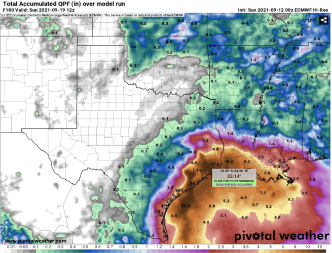
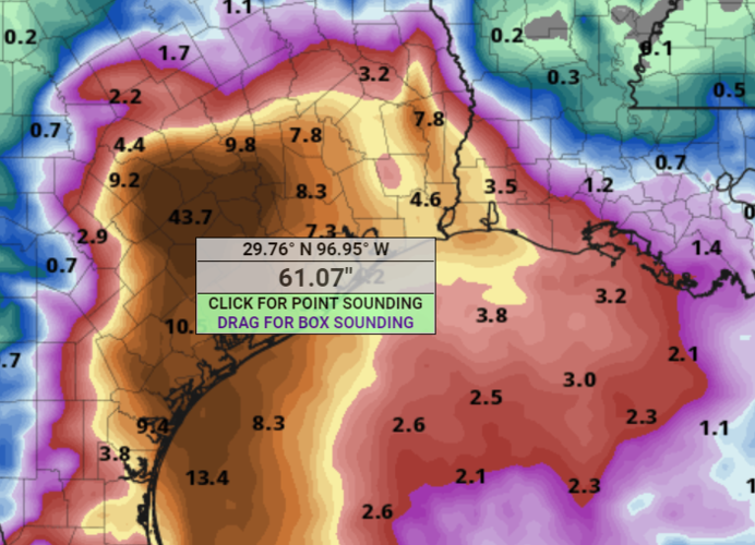
But, if he is sold on the Euro then he better up his rainfall totals significantly. The Euro solution is a much bigger impact even if it is weaker. Sets that 33" rainfall bullseye right over Winnie, Tx. Same spot that got hammered by Imelda. Then enough rain to really cause problems in Houston. The potential for this thing to cause major problems keeps increasing. Hopefully model trends start to swing back the other way soon.
1631457547469.png
 
I'm not really a fan how he discounts the GFS again. Same mistake everyone made with Ida and with Olaf. Olaf was forecasted to have minimal impacts along the the Mexican coast due to west track shown by all the models excpet GFS. GFS continually showed a much farther East solution. Everyone discounted it and then Olaf hit as a near major hurricane right over Cabo. Ida was the same thing. Euro and most models were continually showing a path towards Morgan City or even West of that. GFS kept showing a landfall near Port Furchon. However, given the current forecast intensity (I think he did a good job here), the exact track really doesn't matter all that much.

But, if he is sold on the Euro then he better up his rainfall totals significantly. The Euro solution is a much bigger impact even if it is weaker. Sets that 33" rainfall bullseye right over Winnie, Tx. Same spot that got hammered by Imelda. Then enough rain to really cause problems in Houston. The potential for this thing to cause major problems keeps increasing. Hopefully model trends start to swing back the other way soon.
I don’t see how he’s discounting the GFS completely. He acknowledges the forecast track is a possibility, but is more on the NHC track. His latest is below where he does mention the GFS keeping it more offshore. I can’t really say why he’s not discussing the possibility more, but since this is his job he may be being more conservative in his forecasting. There’s time to change if needed.

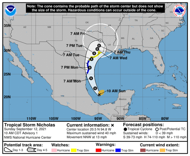
Tropical Storm Nicholas forms in the SW Gulf of Mexico

Tropical Storm Warnings are issued the Mouth of the Rio Grande to Port Aransas TX

Tropical Storm Watches are issued from Port Aransas TX to High Island TX including Matagorda and Galveston Bays.

Storm surge watch is issued from mouth of the Rio Grande to High Island TX

Discussion:

USAF mission into 94L this morning has closed off a low level circulation and found a large area of 40-50mph winds to the north and northeast of the circulation. Additionally, satellite images show an expansion of the scattered deep convection associated with the system. Based on this the system is upgraded to TS Nicholas. The storm is moving NNW at 13mph and this motion is expected to continue today.

Track:
There has been little change in the forecast track reasoning with Nicholas expected to move NNW then turn N and move along the eastern MX and S TX coast tonight and Monday and then turn NNE toward Matagorda Bay late Monday into Tuesday. Nicholas is expected to make landfall over the Matagorda Bay area NHC track is in good agreement with the guidance clustering, although the GFS continues to hug the eastern side of the clustering with a track a bit more toward the east and offshore.

Intensity:
Nicholas will be moving over warm waters of the western Gulf of Mexico in fairly favorable upper level conditions and steady intensification is likely up to landfall. Most guidance maintains the system as a mid range TS and the NHC forecast is for a 65mph TS at landfall which is near the upper end range of guidance. A reasonable worst case potential is a category 1 hurricane, but at this time this looks unlikely.

Impacts:
Will bump up the winds across the Matagorda Bay area into the 55-60mph range and likely spread that NE some into Matagorda County. Tropical storm force winds are likely over the coastal portions of Brazoria and Galveston Counties as well as Bolivar and in Galveston Bay.

Storm surge/tide values of 2-4 ft above normal dry ground will be possible along much of the TX coast.

No changes to the rainfall forecast, but may need to expand higher totals inland some along and east of the track…for now will leave as is.
 
I don’t see how he’s discounting the GFS completely. He acknowledges the forecast track is a possibility, but is more on the NHC track. His latest is below where he does mention the GFS keeping it more offshore. I can’t really say why he’s not discussing the possibility more, but since this is his job he may be being more conservative in his forecasting. There’s time to change if needed.
I like him, he is very good. I also never said he completely discounted the GFS but it is discounted when it should be weighted slightly over ensembles. Just not liking how much slower the general consensus is to change outdated data on models. NHC actually went this route on the initial track.

I know I'm being picky but the same mistake could have ended badly on the last two hurricanes.
 
Latest GFS run is farther West but so is the new Euro run which is now bringing the system in between Corpus and Brownsville. Euro has become even more aggressive with rainfall totals. GFS is putting widespread 12" over Houston metro. Euro is getting downright scary.
1631471119551.png


Even a blend of the two models is pointing towards a high end flood event.
 
And my memories from Ike are popping up on my Facebook feed today...but this one is reminding me a bit more of a Harvey type. We're doing a bit of prep here...mowed the lawn, making sure we're stocked with groceries in case roads are flooded, etc. If the winds start to blow up, we'll bring in outdoor stuff and prep for power loss.
 
And my memories from Ike are popping up on my Facebook feed today...but this one is reminding me a bit more of a Harvey type. We're doing a bit of prep here...mowed the lawn, making sure we're stocked with groceries in case roads are flooded, etc. If the winds start to blow up, we'll bring in outdoor stuff and prep for power loss.
If models don't start to back off on rainfall totals by tomorrow morning might be time for it's own thread.
 
Sunday PM update from Lindner. I expect he’ll start getting more granular with SETX watershed impacts in a day or 2.

Significant rainfall event likely over portions of SE TX…resulting in dangerous flash flooding.

Hurricane watch issued from Port Aransas to Sargent TX

Tropical storm warning extended N to Freeport TX

Tropical Storm Watch remains in effect from Sargent to High Island

Storm surge warning from Port Aransas to San Luis Pass.

Discussion:

Nicholas is becoming better organized over the SW Gulf of Mexico with numerous curved bands and an increase in scattered to numerous deep convection. Nicholas is moving NNW at 15mph and this motion is expected to continue for the next 12-24 hours. The center of Nicholas appears to have reformed to the northwest this morning. TS force winds extend outward 105 miles mainly to the north and east of the center.

Track:
Nicholas will move NNW and then turn as the system rounds the western edge of high pressure over the eastern Gulf of Mexico. This will bring Nicholas close to the lower TX coast later on Monday and then into the Matagorda Bay area on Tuesday. Track guidance is tightly clustered on this track reasoning.

Intensity:
Nicholas will be over very warm waters and generally favorable conditions as it moves up the western Gulf coast and guidance continues to suggest a mid to strong range tropical storm. However a weak hurricane is certainly possible and residents should be planning for such.

Impacts:

Rainfall:

Significant rainfall is expected along and east of the track of Nicholas.

While rainfall totals are indicated over the 5 -7 day period, much of the rainfall is expected to fall over a 2-3 day period starting later tonight.

Coastal counties: widespread 10-15inches (iso 20 inches)

South of I-10: widespread 8-12 inches (iso 15 inches)

North of I-10: widespread 4-6 inches (iso 8 inches)

Flash flood will be possible and WPC has outlooks portions of the area in slight and moderate risks of flash flooding Monday into Wednesday.

Tides:
Storm surge values of 3-5 feet from Port O Connor to Sargent and 2-4 feet from Sargent to High Island above normal dry ground. Some significant inundation is possible around Matagorda Bay. Additionally, waves on top of the surge will result in significant beach erosion and wave run-up.

Winds:
Sustained winds of 60-65mph will be likely around Matagorda Bay with 50-55mph into coastal Brazoria County and Matagorda County. Winds of TS force will be possible over Galveston Island and Galveston Bay. Those in the hurricane watch area should be prepared for hurricane conditions.
 
Errrr…I brought my generator and cords to Thibodaux on Friday to make up for a downed Generac…I didn’t even know about this other storm until my wife mentioned it an hour or so ago..
 

Create an account or login to comment

You must be a member in order to leave a comment

Create account

Create an account on our community. It's easy!

Log in

Already have an account? Log in here.

Users who are viewing this thread

    Back
    Top Bottom