Lakeshore Drive (2 Viewers)

****** neighbors! They make Brees show up to city hall to explain a sandwich shop? that is pretty pathetic don't you think? Guidry could have to the rich folks to get a life. Guidry was the one responsible for ordering a dumb study on the stadium.

The ordinance required the study.
 
She was not "against" the stadium. She simply wanted to stop the Mayor from pushing through the approval prior to an ordinance that was designed to let the neighbors in the stadium area to be part of the approval process. The ordinance was approved prior to the stadium being announced, but the Mayor wanted to circumvent it by pushing the stadium through prior to the ordinance taking effect. It was the people in the neighborhood who did not want that to happen and the council member simply represented the people who live in her district. Which is really her job isn't it?

It's a little different than how you put it, St. Widge. As the City of New Orleans Zoning Ordinance is written, and based on the zoning map in place, Tulane was already allowed BY LAW to build a stadium. No zoning changes were needed, no variances for height, nothing that needed to go before the City Planning Commission, or the City Council, or the mayor for approval, just building permits and the like. Same as if you had a piece of land zoned for a single-family house, and had plans to build a house under existing codes, setbacks, etc. And the Stadium had obviously been "announced" as people knew about it, but the key is that they had not formally submitted building plans for approval. What Guidry did was listen to the howls of the nearby residents, pushed for a narrowly-worded moratorium that clearly was aimed at only the Tulane Stadium development, while the zoning of that area and the language in the zoning ordinance was studied and perhaps changed. It would have never stood up in court. You can't have land zoned in such a way as to allow a Wal-Mart, know that Wal-Mart, Inc. purchased the property and announce they're designing plans to develop a Wal-Mart store on the site, only to have neighbors say "Well, we don't want a Wal-Mart here", or "We want to help decide how the Wal-Mart looks or operates" and politically put a moratorium on department stores, pending changing the zoning ordinance or zoning map.... As a result, Tulane met with neighbors and gave them a few crumbs, and the whole thing went through.
 
I stand corrected! Guidry was against Tulane Stadium and Drew Brees, Palmer quit cleaning the QTR because the pressure washers did damge to streets supposedly. I get them confused. But you get the point they are behind supporting the rich neighbors and I'm sure Lakeshore Drive falls in the same circumstance.

What do you mean "against Drew Brees"? I am all for Drew Brees, but I am against crappy chain sandwich shops on Maple St.
 
Regarding the question at hand-- the Lakefront-- there are multiple reasons for its change.

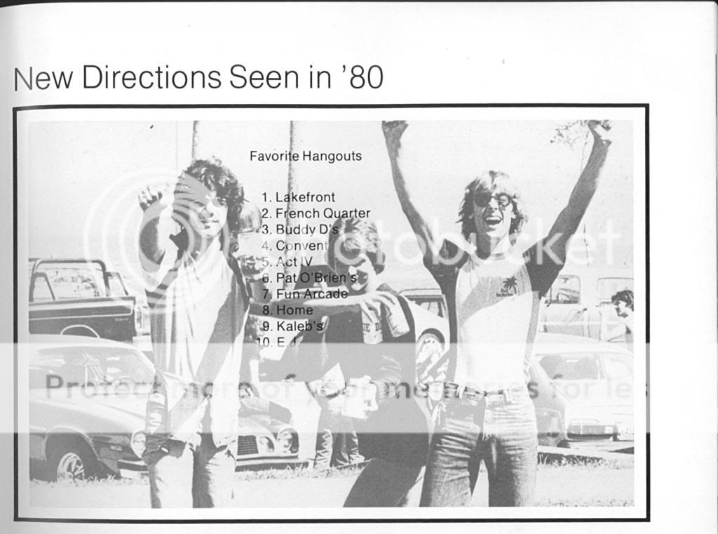
First of all, this 1st photo should give everyone a chuckle:
Lakefront.jpg

source: 1980 East Jefferson High School Yearbook

That's what a lot of people remember. That's what a lot of people wish it still was, at least socially. That's what a lot of posters envision the Lakeshore and Lake Vista folks wanted to get rid of. To some degree, they did. Prior to Katrina, in the early '90s at least, the Orleans Levee District was flush with cash from the casino at South Shore Harbor and other sources. And as we know now, they certainly weren't spending that cash on levees (note that while the OLD was a state-chartered agency, they weren't state-run and certainly not being controlled from Baton Rouge. Much the same as the Sewerage and Water Board of New Orleans). One area in which they spent their money was building up the OLD police, who began aggressively patrolling not only the Lakefront, but also "helped out" by making sure they cut through the adjacent neighborhoods of Lake Vista, Lake Shore, etc. as much as possible on their rounds. Also, look at how the OLD, influenced by the neighbors, eliminated vehicular access to the shoreline roadway behind the fancy houses on Lakeshore Drive between the Paris Ave. circle and London Canal. Now that whole area is like those houses' backyard park.

But you know what? At the time that 1980 picture was taken was near the tail end of the baby boom. Since then there has been less youth from Metry and Kennahbrah to come over and blast Zeppelin out of house speakers lodged in their open trunks on Sunday afternoons; a better ratio of kids to OLD cops-- especially in the late '80s and '90s.

Through this all, there were also physical changes-- the levees were raised, gates were installed at roadways, shelters and simple canopied pavilions were removed/replaced, they started shutting down lanes of traffic on weekends to dedicate lanes for cyclists and joggers, etc. But still, the Lakefront looked NICE, not much different than it did in its heyday:

RobertSeawall.jpg

source: a poster-sized photo on the wall at the Robert E. Lee Robert's

Look at the size and amount of TREES in that shot! Look at the neat clean roadway! Even in the mid 1990s, the Mardi Gras Fountain worked, the Lake was getting cleaned up, it was still pretty. Good times.

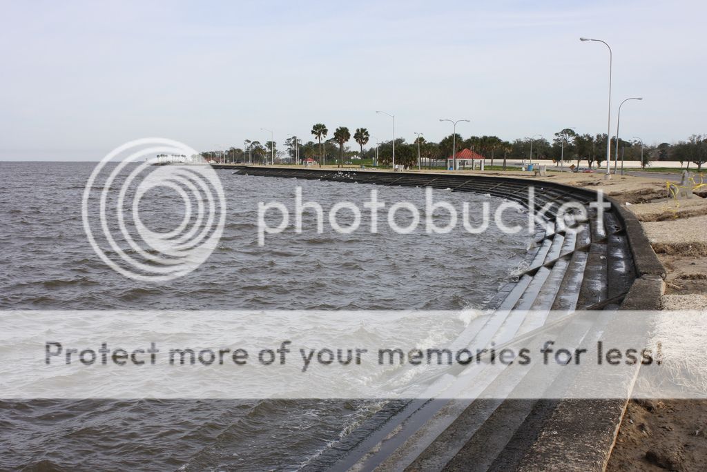
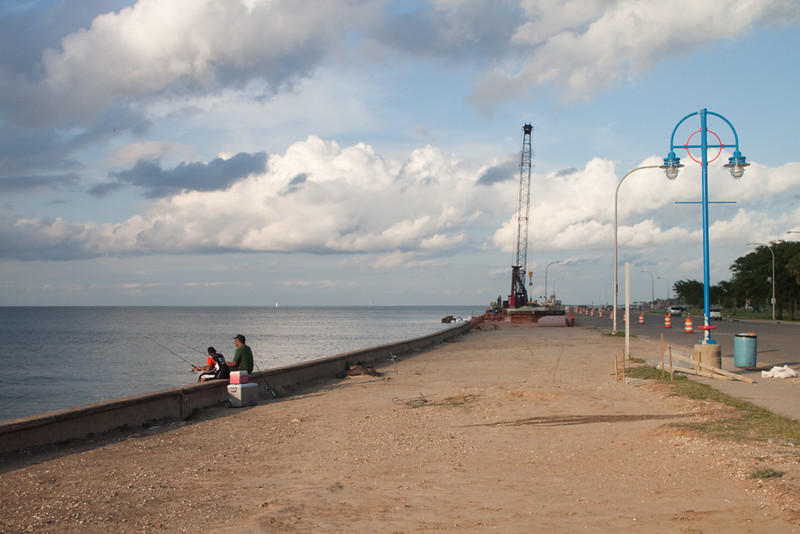
Since Katrina, trees have died and continue to die. No one keeps up the area; as the OLD is no more. What's more, erosion between the roadway and seawall is a HUGE issue, whereas I don't remember it ever being an issue back in the 70s -90s. Similarly, subsidence between the roadway and the levees also seems to be a problem, where it wasn't before. Whether it's global warming, higher lake levels, or what, the water always seems higher on the steps than it did in years past. Compare the above pic to this recent one:
seawall2010.jpg


About 11 visible steps versus 7. I know there are tides and waves, but still-- 4 steps difference? I'm thinking the seawalls, the roads, the whole works is SUBSIDING lower. And that's a HUGE and expensive problem
 
Regarding the question at hand-- the Lakefront-- there are multiple reasons for its change.

First of all, this 1st photo should give everyone a chuckle:
Lakefront.jpg

source: 1980 East Jefferson High School Yearbook


Good post.. But I think the biggest takeaway in all this is: Buddy Diliberto had a bar?? How did I not know this? Where was it?? I need details.
 
Got my first booty on the lake. Shame.

Sent from my SPH-D710 using Tapatalk 2
 
Lakefront.jpg


I thought this pic was right out of Dazed and Confused......:hihi:
 
Look at the size and amount of TREES in that shot! Look at the neat clean roadway! Even in the mid 1990s, the Mardi Gras Fountain worked, the Lake was getting cleaned up, it was still pretty. Good times.

Since Katrina, trees have died and continue to die. No one keeps up the area; as the OLD is no more. What's more, erosion between the roadway and seawall is a HUGE issue, whereas I don't remember it ever being an issue back in the 70s -90s. Similarly, subsidence between the roadway and the levees also seems to be a problem, where it wasn't before. Whether it's global warming, higher lake levels, or what, the water always seems higher on the steps than it did in years past. Compare the above pic to this recent one:
seawall2010.jpg


About 11 visible steps versus 7. I know there are tides and waves, but still-- 4 steps difference? I'm thinking the seawalls, the roads, the whole works is SUBSIDING lower. And that's a HUGE and expensive problem

Not saying that area isn't subsiding, but you have to remember the lake is an estuary, was the tide way up when that pic was taken?
 
Looks like they're about to get things going on fixing the seawall. Good to know they didn't forget the lakefront.

WWLTV.com said:
NEW ORLEANS -- Officials broke ground on a $6.2million project that will strengthen storm protection along 3,900 feet of the seawall Lakeshore Drive -- a length of roughly four football fields.

Local residents have seen the pictures of Lakeshore Drive filled with lake water after a Hurricane like Isaac or even when a winter storm blows in and the lake water pounds the seawall and undermines the concrete.

“It hits the dirt behind the seawall, and washes all of that dirt onto Lakeshore Drive, making Lakeshore Drive impassable for weeks and costing tens of thousands of dollars every time to clean up the debris,” said Tim Doody, president of the East Bank Levee Authority.

When the water goes out, it erodes the dirt underneath the seawall. This new project will install vinyl sheet piling to prevent that in the future. The continuous vinyl sheetpile wall will run the length of the project behind the seawall.

“That will prevent the water from penetrating between the monolith joints and also undermining that’s going on from underneath the seawall steps themselves,” said Gerry Gillen, executive director of the Orleans Levee District.

“So we hope that with this project and the two that will come up behind it will arrest the problems presented to us by the lake,” said Doody.

Officials breakground on Lakeshore Drive seawall upgrade | wwltv.com New Orleans
 
3900' for $6.2 million or about ~$1600/lf??
SMH.

Just another reason why this country is in the shape it's in.:aargh:
 
Slightly off-topic, but one of the regular practices has been to close it at night due to lack of lighting. A couple weekends ago, the barrels were moved and a few brave souls wandered into the darkness along the Lakefront. It was definitely one of the more enjoyable rides I've had in this city - like you weren't supposed to be there but were damn glad you were.
 
Good to see that they've decided to do something about the seawall but it stills presents the question of why it's been allowed to to deteriorate to the state that it's in now. Maybe some of the posters here are too young to remember what Lakeshore drive was like in the 60's and 70's. All of the same problems that they're currently using to blame for the current condition of the area were present then too.

I took this picture yesterday. Look at this! It's a disgrace.
IMG_5463-L.jpg
 
Last night FOX 8 had a good news piece on the rebuilding of Lakeshore Drive. Link to video:

FOX 8 WVUE New Orleans News, Weather, Sports - Lakefront Improvements

Watch at about the 1:30 mark; it gives creedence to what I've been posting-- water levels are up and/or the seawall (and everything behind it) has been subsiding. They have even older photographic evidence than I did and did the same type of step count.
 
Just got wind of this video-- pretty much sums up the Lakefront of old. Some great footage and background music from car radios and such:

<iframe src="https://www.facebook.com/video/embed?video_id=4930139691575" width="320" height="240" frameborder="0"></iframe>
 

Create an account or login to comment

You must be a member in order to leave a comment

Create account

Create an account on our community. It's easy!

Log in

Already have an account? Log in here.

Users who are viewing this thread

    Back
    Top Bottom