Severe Weather alert for Tuesday across most of central US (1 Viewer)

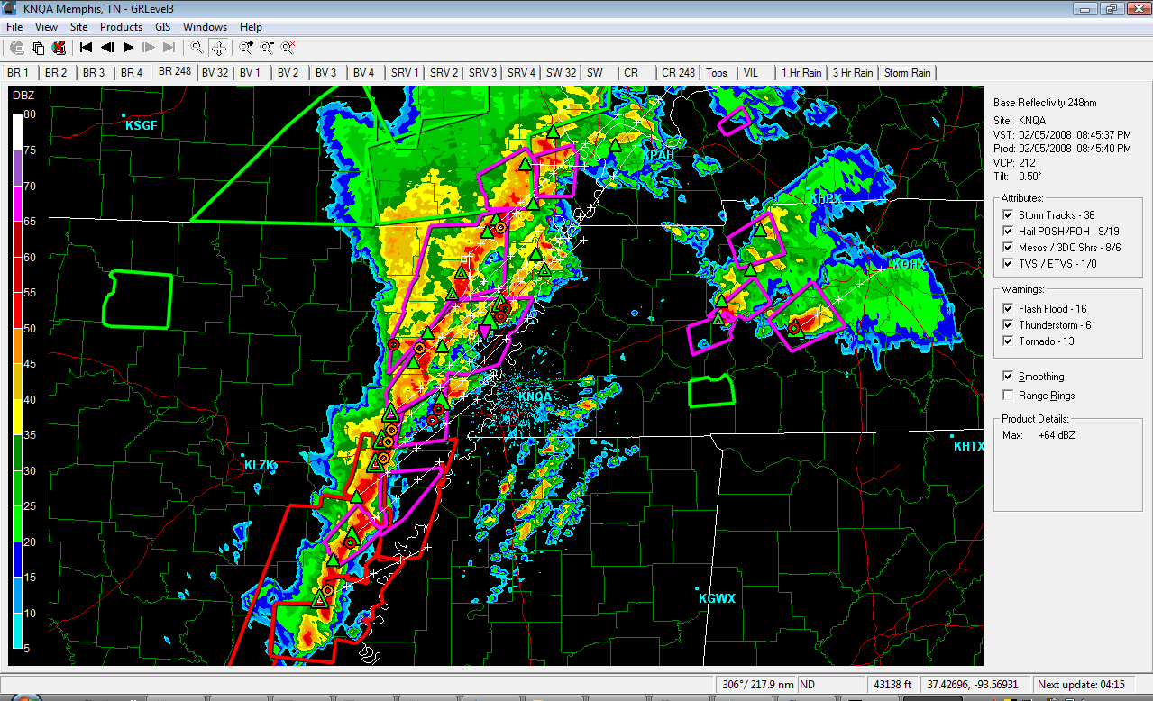
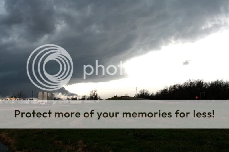
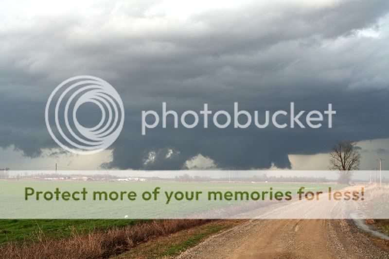
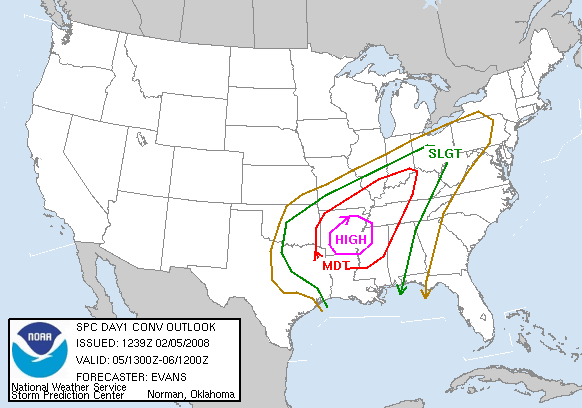
North La, Ar, Ms and Tn will see some extreme weather today. If you are in these areas then take the tornado warnings serious.
highrisk.gif


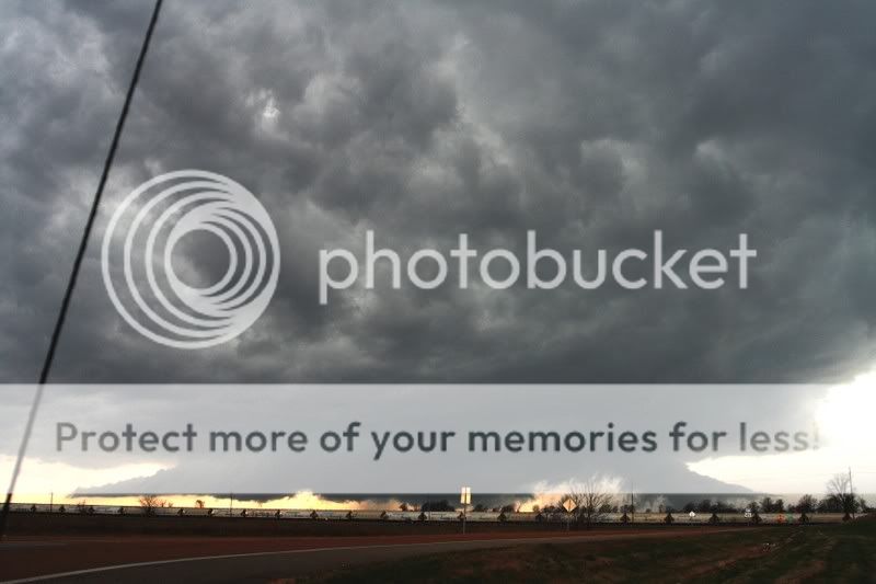
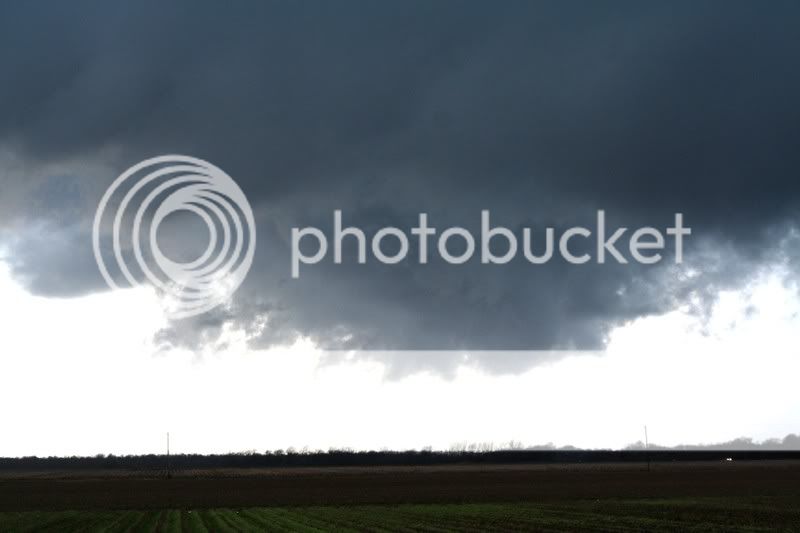
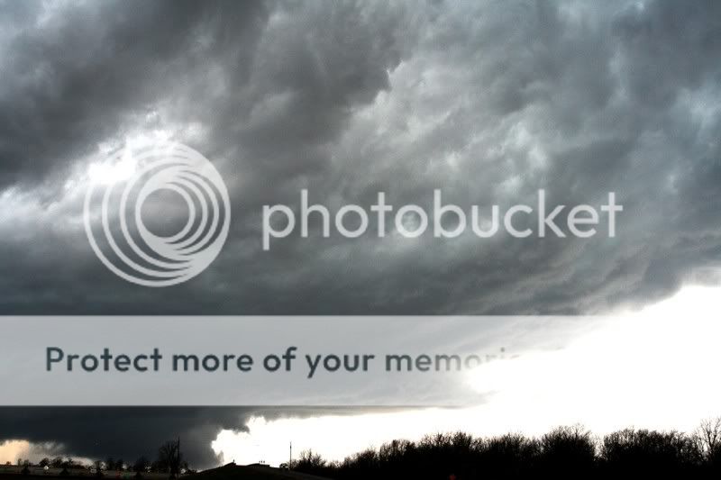
I'm off to Greenville, hopefully will have some nice pics tonight.
 
TN/AR are getting it a lot worse than here.

 
Last edited:
Yeah.....the first wave hit parts of Memphis hard......and the second wave is getting ready to hit.....
 
Nashville looks like it got clocked by a supercell a little while ago. Any reports?
 
You guys take care. I usually hate the dramatics of the weather channel, but I've got it on tonight, hoping that everyone I know throughout the affected areas are safe and sound. Our prayers for your safety are going out big time.
 
We've had about 2 inches of rain here today, and right now were gettin hammered with some bad lightening. very unusual for this time of year.
 
Just got back from a very long chase. I didn't see any tornadoes but got on some beautiful storms. I avoided the Memphis area because it is so hard to chase in the city but it was pretty difficult to chase anywhere today with storm motions up to 80mph. The best storm we got on today was one that started in Alexandria as a small thunderstorm. We picked up on it in Southern Arkansas and chased it all the way to Batesville, Ms.

So far 52 tornadoes have been reported, several deadly and several extremely damaging. I will post some pics tomorrow but I'm beat.

For those in the areas that got hit, I hope you made it ok.
 
Storm Prediction Center will likely issue a tornado warning for almost all of SE La.
 
These were taken just outside of Lake Village, Ar yesterday afternoon. This cell didn't produce a tornado until it got up near Nashville. It did produce some baseball size hail and registered wind gust of 86mph

02-05-2008-b.jpg

02-05-2008-n.jpg

02-05-2008-i.jpg

02-05-2008-e.jpg

02-05-2008-q.jpg
 
Last edited:
Tornadoes in U.S. South Kill 48 in Rare Winter Strike (Update5)

By Demian McLean

Feb. 6 (Bloomberg) -- Tornadoes swept through the southern U.S. late yesterday, killing at least 48 people, sparking a pipeline explosion in Tennessee and ripping the roof off a building at FedEx Corp.'s main airport hub.

The ``extremely dangerous'' twisters, spawned by unseasonably warm temperatures, prompted the first high-risk weather alert issued in February in 10 years, AccuWeather.com said. Heavy rain, damaging winds and hail are possible from the Carolinas to southern New Jersey today, AccuWeather said.

http://www.bloomberg.com/apps/news?pid=20601103&sid=adPftJQe_r_c&refer=us
 
Wow. The wall cloud was really low. Luckily we didn't have anything like that around here. But we did have a line of storms develop quickly. I checked the radar and there were maybe 2 cells over the Dallas area. It took me 15 mins to drive to the gym and start working out and that's when the TV stations broke in with the severe weather alerts. The line had formed that quickly.

I hate severe weather season.
 
The stuff in Dallas blew up along the shortwave and went severe in a couple frames. One storm around the Paris area looked like a beast on radar.

The wall was spinning like a top but for some reason it just never would drop a tornado. The environment it was in had crazy shear with 0-1 helicity values around 550. It was completely isolated, had a huge core, nice inflow tail and instability certainly wasn't an issue. I guess it wasn't close enough to a populated area. Those storms were evil yesterday. They would go for 100+ miles without dropping a tornado but the second it got near a populated area they would put down some monsters.

The death toll is extremely high but considering the population of the areas they hit it could have been much worse. The storms were hauling *** but the NWS did a great job of issuing warnings two counties ahead of the storms to give plenty of lead time. I have never seen so many spotters and chasers this far south before and I'm sure that helped.
 
I wonder if with even putting out the warnings 2 counties ahead, people still didn't heed it since the storms were so far away. Many people may not have realized the storms were traveling 50+mph is some cases. That will come upon you quickly. It might look decent outside when the warning is issued, then 10 mins later it looks like the world is coming to an end.

From that middle pic, you can get an idea of the rotation. Post a pic of the baseball sized hail you have one.
 

Create an account or login to comment

You must be a member in order to leave a comment

Create account

Create an account on our community. It's easy!

Log in

Already have an account? Log in here.

Users who are viewing this thread

    Back
    Top Bottom