Offline
OK - it is now time for it turn East!!! It is getting closer and closer to me in South Alabama. The waves was getting pretty good size yesterday at Perido Key. There was a few guys getting setup to surf.
Follow along with the video below to see how to install our site as a web app on your home screen.

Note: this_feature_currently_requires_accessing_site_using_safari
Getting ready for rain and some fair amount of wind in Charleston.
I'm supposed to be flying to DC on Saturday morning. Hopefully she's moved out by then.
I'm going thru CLT Friday morning to Negril. Looks like I may stay in front of it.

Labor weekend at Hedonism, hmmmmm.

USAF mission has confirmed that the tropical storm is now a hurricane…the first hurricane in the Gulf of Mexico since 2013. Hermine will landfall as a hurricane into FL this evening…the first hurricane to strike FL since 2005.
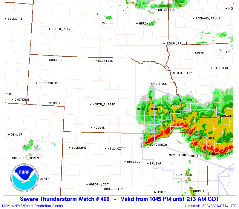
See graphic below for numerous watches/warning that are in effect for the US Gulf and East coast.
Discussion:
Hermine continues to intensify this morning and now afternoon with the central pressure haven fallen from 1002mb yesterday evening down to 988mb on the last recon pass. Flight level winds of 77kts were recorded and both the radar and satellite presentation looks good with deep convection having wrapped around the center of the system. Radar images out of Tallahassee show a well developed and large eye like feature. This afternoon is the first time deep convection has successfully wrapped all the way around the center. Given the steady intensification today and continued fairly favorable conditions…Hermine will likely continue to strengthen up to landfall early on Friday.
Hermine is tracking to the NNE at 14mph and this motion is expected to continue with an increase in forward speed. On this track the center of Hermine will cross the NW FL coast late tonight or early Friday morning south of Tallahassee in the NW portion of Apalachee Bay. The system will then track NNE to NE across S GA and across the Carolinas and then offshore the mid-Atlantic by Sunday where it slows down and potentially stalls east of the New Jersey coast and south of New England. The extended portion of this forecast remains of low confidence due to the complex interaction this system will have with a departing trough and building upper level blocking ridge of high pressure over the NE US and SE Canada.
Impacts:
Significant and extensive storm surge flooding is imminent along the NW/N/NE coasts of Apalachee Bay. This area is extremely storm surge prone to a NE moving tropical system with a long fetch SSW feed into the Bay. The tropical storm force wind field has expanded this morning and will only help to push even larger amounts of sea water into the bay. This process is already underway and water levels along the coast will begin to rise rapidly this evening and peak overnight into Friday morning. Life threatening storm surge inundation of 6-8 ft above ground level will be possible at the head of Apalachee Bay which will submerge coastal structures that sit on the ground to near the roof line. Additionally large battering waves of 8-12 ft will accompany this storm surge producing extensive damage to coastal structures. Persons should not under-estimate the potential storm surge threat and how much the sea water is going to rise…just because it is a minimal hurricane. The shape of the coastline in this area and direction of approach along with the long fetch and expanding wind field is going to produce a formidable storm surge event.
The link below is a live camera at Cedar Key, FL and you can clearly see how low the area is and how potentially significant a 4-8 ft storm surge will be in this area.
http://www.ustream.tv/channel/YASbYUZFccF
Expect hurricane force winds to be felt near and just to the east of the center landfall…which may bring hurricane force winds across or very near Tallahassee late tonight. A large area of tropical storm force winds will impact much of central and northern FL into much of central and southern GA into Friday. Tropical storm force winds will then move up the SE US coast into SC and NC Friday afternoon into Saturday and across the mid-Atlantic Saturday night into Sunday. It is too early to determine potential wind impacts over the NE US Sunday into Tuesday as much depends on just how tropical…if at all Hermine remains…or it the system expands outward into an extra-tropical system.
Rainfall amounts of 8-15 inches is likely along and to the right of the track of the center across N FL into SC GA and much of SC/NC. Extensive flooding will be possible over N FL and SC GA into SC over the next 12-24 hours as this sustained rainfall moves inland.
This is really overdue.
Hermine? Really Harry Potter is getting named Hurricanes before me? Windgardium Leviosa *****es!