***TROPICAL ALERT*** Hurricane Sally (Tropical systems are going into 2020 mode) (2 Viewers)

I meant to post the image in this thread, but posted it in the Laura thread by mistake. The 120 Hr. Euro has the mouth of
the Ms. in the crosshairs. It concerns me because the GFS is also in agreement.

ecmwf-uv850-vort-seus-6.png
 
I meant to post the image in this thread, but posted it in the Laura thread by mistake. The 120 Hr. Euro has the mouth of
the Ms. in the crosshairs. It concerns me because the GFS is also in agreement.

ecmwf-uv850-vort-seus-6.png
Louisiana is obviously a hurricane magnet. :covri:
 
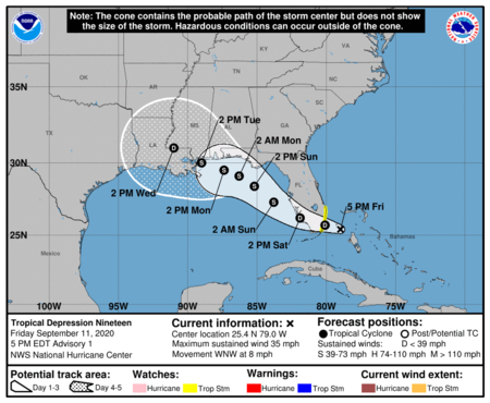
NHC advisory #1

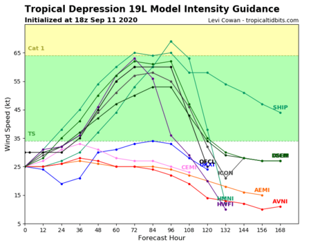
after the system reaches the eastern Gulf of Mexico, steady intensification is expected through the weekend due to expected light wind shear and very warm water. Some increase in shear could occur over the northern Gulf of Mexico but that is uncertain at this time. The first forecast will stay conservative and only show a peak intensity of 60 kt in 3 to 4 days, but do not be surprised if that is revised upward on later forecasts once other models better initialize the depression.

More bad news as it's currently traveling only 8mph which will give it more time over very warm waters
 
The first forecast will stay conservative and only show a peak intensity of 60 kt in 3 to 4 days, but do not be surprised if that is revised upward on later forecasts once other models better initialize the depression.
Not good.
 
Seriously 2020, fork you.
 
No it isn't. I'm starting to get bad vibes from this one. Once a TS enters the gulf, there is no escape route. It will eventually
make landfall. We are also at seasons peak. There is nothing in the near future to prevent it from intensifying. Warm water
no shear and a anti-cyclone in the upper atmosphere are a bad recipe
Agreed. I think this one could be really bad news.

Weather Channel is also showing this sucker basically taking 3 days to get from Mobile to New Orleans. Rain will be significant, too.
 
The first track’s usually never correct . There are always adjustments. I’m just going by history here. I’m hoping it moves more east when in the gulf. Hope for a miracle and the Everglades take the punch out of this storm .
 
The first track’s usually never correct . There are always adjustments. I’m just going by history here. I’m hoping it moves more east when in the gulf.
I think the path on this one is much more clear than Laura was.
 
Sorry y'all been busy and forgot to check in here about the very active Atlantic Basin.

Let's talk about newly minted TD 19... Look like the center will pass just south of my place.


1599862176399.png

1599862220306.png

1599862278117.png


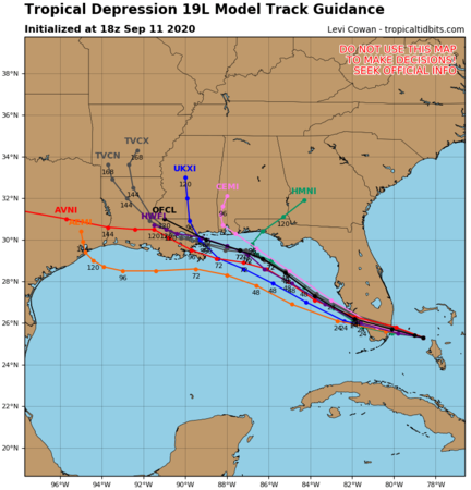
HWRF has it skimming the MS coast and staying north of both lakes. Before that, it looks like it will center on Cutler Bay, FL, just north of Homestead air base, south of Miami. About 45min south on the interstate from me...
Looks like most models show a TS and the Euro shows it going from Lake Borgne to Lake Pontchartrain.
 

I think i'll be in for a lot of rain tonight and tomorrow...
 

Create an account or login to comment

You must be a member in order to leave a comment

Create account

Create an account on our community. It's easy!

Log in

Already have an account? Log in here.

Users who are viewing this thread

    Back
    Top Bottom