- Joined
- Oct 24, 2000
- Messages
- 14,819
- Reaction score
- 13,141
- Age
- 46
Offline
If there hadn't already been so much devastation, this would almost be comical at this point. 
Follow along with the video below to see how to install our site as a web app on your home screen.

Note: this_feature_currently_requires_accessing_site_using_safari
A tropical depression or tropical storm is likely to from over the NW Caribbean Sea
A slow moving tropical wave over the NW Caribbean Sea is becoming better organized and a tropical system will likely form in the next 24 hours. The system will move generally slowly toward the NW over the next 48 hours and into the southeastern Gulf of Mexico. Conditions are mostly favorable for some development of this feature, but upper level winds over the Gulf of Mexico may become hostile for additional development by early to mid next week. The overall track steering is in the general direction of the central or eastern Gulf of Mexico over the next 4-5 days.
Jeff Lindner
Director Hydrologic Operations Division/Meteorologist
Harris County Flood Control District
Tropical Depression forms over the NW Caribbean Sea…a threat to the US Gulf coast.
Discussion:
TD 28 has become better organized today with a broad low level center having formed to the southwest of the Cayman Islands. It appears the low level and mid level centers are currently not aligned, but with favorable upper level conditions in place these two centers should eventually align. There are numerous curved bands and weak to moderate scattered convection near the low level center. The depression is drifting to the NNW at 2mph and a general slow motion is likely for the next few days.
Track:
TD 28 is south of a building mid level ridge of high pressure over FL and this will induce a slow NW to WNW motion toward western Cuba and the southern Gulf of Mexico by early next week. After 48 hours the system will begin to feel the influences of an approaching deep layer trough and cold front over TX and will turn toward the right (north) and accelerate in forward speed. The major global models are in decent agreement on the track of this system, with once again the exception of the ECWMF which shows a significantly westward track and landfall over SW LA. This model has had a significant west bias this hurricane season with Laura, Sally, and Delta. The GFS, HWRF, and CMC show track generally toward the central or eastern US Gulf coast from SC LA to the FL panhandle.
Intensity:
Conditions are favorable for development once a well defined low level vortex becomes defined with good upper level outflow and a large envelope of moisture along with warm sea surface conditions. Some land interaction with both western Cuba and portions of the Yucatan could hold back the intensity some, but a hurricane is forecast in the southern Gulf of Mexico. After Tuesday, as the system begins to turn northward, strong upper level southwesterly winds ahead of the approaching trough over TX should result in some degree of weakening as the system lifts northward over the Gulf of Mexico. Similar to Delta, with an incoming trough from the west, an expansion of the wind field will be possible over the northern Gulf of Mexico.
Jeff Lindner
Director Hydrologic Operations Division/Meteorologist
Harris County Flood Control District

Welp. All of SC/SELA in the cone.
 www.wwltv.com
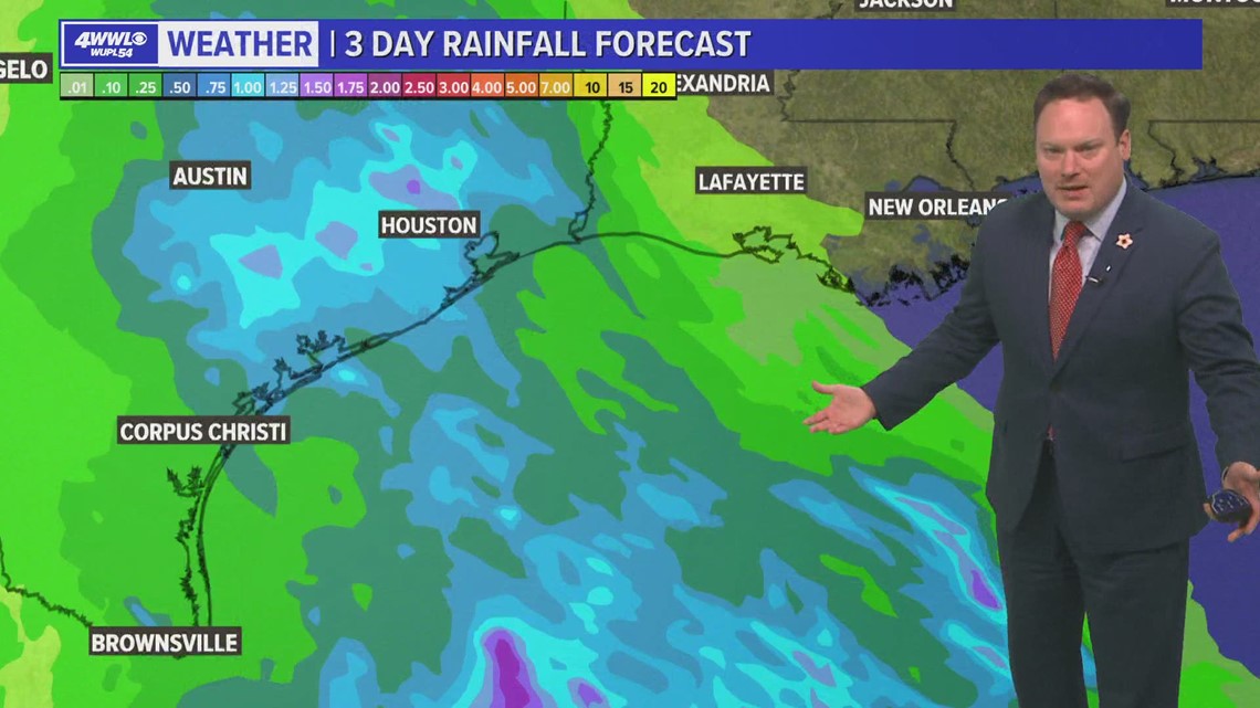
At this point it looks like we may get some rain from it on Wednesday and possible early Thursday. However, another cold front that may arrive late Wednesday and keep big impacts away from us. Plus it may stay a messy system where most of the rain is displaced far east of the center.
A few things we have going for us is that this likely won't be extremely intense at landfall. The current forecast is for a tropical storm. Also, it will be moving fast - it should accelerate over the northern Gulf due to a trough of low pressure driving the cold front, so it won't hang around for long.
For now, we have rain chances increasing Wednesday with the frontal passage set for early Thursday, then much cooler weather Friday and next weekend.
Yet another tropical storm forms
Hurricane Watches are issued for the eastern and northern coasts of the Yucatan peninsula.
Discussion:
The tropical depression over the northwestern Caribbean Sea has continued to slowly become better organized and recent satellite overpass and a USAF mission has determined that winds have increased to near 40kts. While the mid level and low level centers remain unaligned, the low level center has become gradually better organized. Overall Zeta has not moved much in the last 12 hours, however the center has appeared to relocate southward due to convective “tugging” with a large mass of deep convection south of the center and also likely some degree of steering from the mid level center located to the east.
Track:
There will be little motion of Zeta for the next 12 hours as the system is in weak steering flow. On Monday mid level high pressure will begin to build westward across the Bahamas, FL, and into the central Gulf of Mexico allowing Zeta to turn toward the NW and WNW and an increase in forward motion. Global and hurricane guidance is in good agreement on this track reasoning and on this track Zeta will approach and possibly landfall along the NE Yucatan late Monday into Tuesday. Zeta will then enter the southern Gulf of Mexico and begin to round the western edge of the mid level ridge over the eastern Gulf. A strong and deep layered trough over the western US will progress slowly eastward into the southern plains by mid week and this trough will capture Zeta and turn the system north and likely northeast toward the central or eastern US Gulf coast. There is much uncertainty on how sharp a turn Zeta makes over the central Gulf of Mexico with viable track solutions from Louisiana to the FL panhandle.
Intensity:
Overall Zeta is in a favorable environment for development once the low and mid level centers align. Conditions appears favorable for continued development as Zeta moves across the NW Caribbean Sea and Zeta could be very near hurricane intensity by landfall over the NE Yucatan. Once in the Gulf of Mexico conditions continue to look favorable for intensification over the southern Gulf and Zeta will likely regain or maintain hurricane intensity. As Zeta begins to turn northward over the central Gulf, cooler sea surface temperatures and increasing vertical wind shear should result in weakening of the system as it approaches the US Gulf coast. However, as with Delta, it is unclear how quickly the weakening may occur.
Jeff Lindner
Director Hydrologic Operations Division/Meteorologist
Harris County Flood Control District