bclemms
More than 15K posts served!
Offline
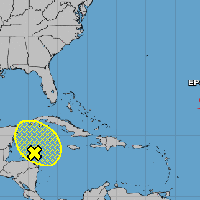
NOAA (more accurately the NHC) isn't models. That is a 20% chance of formation in the next 5 days. Most of the models have development in the 6-8 day range. When I say most of the models I'm referring to the Euro, CMC, GFS and most ensemble members. The Icon does not develop beyond a broad area of low pressure. It'll likely go to 40% by tomorrow evening then 70% by the weekend if model trends continue.Very much? NOAA only has it at 20%
Edit: Nevermind, 18z ICON begins to develop into at least a depression as well but 6z and 18z ICON only go out 120 hours as opposed to 240 hours on the 00z and 12z runs. So all the models develop it into a tropical system of some sort.