- Banned
- #31
Makes sense because you know, it's 2020.

Follow along with the video below to see how to install our site as a web app on your home screen.

Note: this_feature_currently_requires_accessing_site_using_safari
Makes sense because you know, it's 2020.
There's a very good chance we'll see several, It's going to be a busy year.
Well if I had to choose between a June vs an Aug or Sept storm, I'll take June.
Well if you follow some of the professionals that do this for their livelihood, that is a pretty good opinion. And I certainly do.I suspect it's going to be all of the above.
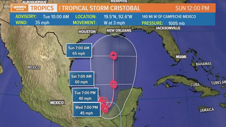

I think we'll see it strengthen pretty quickly as it moves into the central Gulf but I'll be surprised if it can maintain intensity as it approaches the coast due to cooler waters. If GFS is right, it sure looks good for tornadoes in Nebraska on Saturday too. Decisions will have to be made.Both the Euro and GFS, are now becoming more aligned, as of latest respective model runs. Both have a 987-996 millibar system (CAT 1 hurricane), just south of central, to SE coast of Louisiana, come Saturday. The GFS has a landfall around midnight Saturday, south of New Orleans, while the Euro has a landfall around Lafayette. The intensity is always a tricky thing, whereas when these two models begin to align, they are generally pretty much spot on +/- 25 miles, either way of landfall. We shall see, as it is still 5 days out. But confidence of the models is building.

