***TROPICAL ALERT*** TROPICAL STORM ETA (Late season tropical outlook discussion) (3 Viewers)

Super44

Pro-Bowler
Joined
Mar 5, 2015
Messages
7,830
Reaction score
9,811
Age
30
Location
NOLA
Offline
10/5: Deleting and adding more stuff to Super44's ORIGINAL POST.

I'm adding key info to the original post to make it easier to find. I'll add more info as needed. ~primadox
~~~~~~~~~~~~~~~~~~~~~~~~~~~~~~~~~~~~~~~~~~~~~~~~~~~~~~~~~~

NHC PRODUCTS

NHC Home
Tropical Weather Outlook
Atlantic Tropical Weather Discussion

Eta information:
Public Advisory
Forecast Advisory
Forecast Discussion
Wind Speed Probabilities
NHS Local Products
Update Statement
U.S. Watches/Warnings
Key Messages
Link to storm specific satellite imagery


Other links:
NOAA Satellite Imagery (links to various looping images)
WWL Hurricane Central
Mike's Weather Page (lots of links and maps here)
College of DuPage (good site for model runs)
Tropics - wide view (from Hurricane Harbor) - click on the 5 day movie html5 link to animate.
NOAA - Local River Flood level predictions
Jeff Lindner: Facebook page Twitter feed
Space City Weather Facebook page
Saints Report Hurricane Preparedness Tips thread


CURRENT MAPS/FORECASTS/MODELS:

Official NHC Forecast Cone


151835_5day_cone_with_line_and_wind.png


151835_most_likely_toa_34.png


151835_peak_surge.png


Radar Images:

BYX_loop.gif
 
Last edited by a moderator:
I'm hoping that I won't need to add the usual maps and links to the original post in this thread, which would mean that there's nothing worth reporting. 90L can just fizzle out and die.

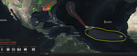
I'm thinking/hoping that 98L will be a fish storm. That would be nice.
 
Lots of uncertainty for sure ATM now. This one may be more challenging then any of the previous gulf systems we have seen this season. A frontal boundary approaching the gulf coast really complicates the forecast. As usual, stay tuned for anyone living along the gulf coast from northern Mexico, all the way over to say the panhandle of NW Florida.
 
Lots of uncertainty for sure ATM now. This one may be more challenging then any of the previous gulf systems we have seen this season. A frontal boundary approaching the gulf coast really complicates the forecast. As usual, stay tuned for anyone living along the gulf coast from northern Mexico, all the way over to say the panhandle of NW Florida.
Models are all over the place right now. I'm seeing landfalls from Nola to Brownsville. That cold front does concern me though.
They can interreact with these storms and pull the more poleward.
 
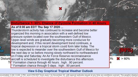
Tropical depression or storm likely forming over the southwest Gulf of Mexico

Satellite images overnight show what is likely an organizing tropical system over the extreme southwest Gulf of Mexico just east of the eastern Mexican coast. Deep convection has developed near or west of what has likely been the formation of a surface low pressure center. A USAF mission will investigate this feature later today to determine if a tropical depression or storm has formed.

Most global model guidance continues to develop 90L and moves it very slowly over the southern Gulf of Mexico as a cool front moves into the northern Gulf this weekend helping to trap the system south of the front boundary. It appears the trough associated with the front will help to help 90L toward the NE into the west-central Gulf of Mexico, but not strong enough to pull the system toward the north-central Gulf. 90L then becomes under the influence of the building high pressure behind the front and will potentially turn westward toward the western or northwestern Gulf of Mexico slowly early next week. There are any number of possible track solutions on the table and confidence in any of the solutions is very low given the overall weak steering patterns that will be in place. It is possible that 90L will be over the Gulf of Mexico for a good portion of next week.

I cannot stress enough how low confidence any forecast solution is at this time with 90L given the various competing track factors and overall weak steering.

As for intensity, overall the pattern looks favorable in the near term for intensification and it is likely that a tropical storm will form as early as later today. Strengthening would be likely over the next 24-48 hours as the system will be over very warm waters in a low shear environment. Over the weekend, a very dry air mass associated with a frontal boundary will move into the northern and portions of the western Gulf of Mexico and some of this dry air may become entrained into the circulation and this could limit development. Most guidance keeps the system as a tropical storm while lingering over the Gulf of Mexico for several days.

Impacts:
The combination of lowering pressure in the southern Gulf combined with building high pressure over the OH valley will produce a moderate to strong pressure gradient over the northern and northwestern Gulf of Mexico starting this weekend and lasting into next week. This is a favorable wind pattern for water level rise along the upper TX coast and using the GFS based extra-tropical storm surge forecast does show coastal water levels nearing 4.0 ft above MLLW by the Sunday high tides. Coastal flooding will be possible as early as Sunday and more likely into next week as the tropical system lingers over the western Gulf south of the upper TX coast resulting in a long fetch ENE/E wind flow.

Jeff Lindner
Director Hydrologic Operations Division/Meteorologist
Harris County Flood Control District
 
Latest EURO, has it approaching the lower Texas coast (no landfall), and gradually working back away from the coast and then moving generally towards the SELA coast, skimming over (just south of NOLA), on its way back over essentially the same exact location where Sally just hovered over for 2-3 days. Then making a 2nd landfall, in pretty much the same spot as Sally. Nothing would surprise me at this point. It is 2020!
 
Believe it or not, the GFS and EURO are getting aligned early on for this system. Pretty crazy considering how far out we are and all of the dynamics in play. The longer it sits, the more probable the EURO and GFS solutions will become likely. Need it to somehow find itself meandering over into northern Mexico where there is virtually no one living in that area.
 
This could go straight to tropical storm status later today, believe it or not. ASCAT winds indicate it could very well be a depression already. Hunter aircraft will know later today what we have.

1600345325221.jpeg
 
Believe it or not, the GFS and EURO are getting aligned early on for this system. Pretty crazy considering how far out we are and all of the dynamics in play. The longer it sits, the more probable the EURO and GFS solutions will become likely. Need it to somehow find itself meandering over into northern Mexico where there is virtually no one living in that area.

The GFS para has it hitting south Texas,moving offshore again,hitting SELA,moving offshore again and hitting the same area
Sally just ravaged. .2020 is crazy.

Here is a quote from a pro met on storm 2k. The experts are struggling with this one.

Models may be having trouble with all the cool, dry air flowing down the western Gulf along the coast of Mexico this weekend. Such flow naturally forms a wave on any cold front. Most models, at least initially, have the low as frontal. Some detach it from the front and drive it west to Texas next Wed-Thu-Fri. I'd much prefer that they are all wrong and nothing but a frontal wave develops. Who wants to come up with a 7-day forecast for me to issue to hundreds of clients tomorrow? Millions of dollars will depend on what is forecast. So much for any time off post-Sally.
 
Last edited:

Create an account or login to comment

You must be a member in order to leave a comment

Create account

Create an account on our community. It's easy!

Log in

Already have an account? Log in here.

Users who are viewing this thread

    Back
    Top Bottom