***TROPICAL ALERT*** TROPICAL STORM ETA (Late season tropical outlook discussion) (2 Viewers)

I'm very surprised Eta didn't hit cat 5. That eyewall and Dvorak scan was indicating it was well into cat 5 intensity. Fortunately, then winds just didn't have enough time to catch up to the pressure before landfall. Really though, it doesn't matter. The storm surge and flooding is going to be as catastrophic as it gets. If the death toll is less than 1000 it'll be good news which is horrifying.
 
Mudslides are going to bury cities.

Question: If it gets downgraded to a LOW and then re-emerges into the Caribbean and becomes a named storm again, does it stay as Eta or does it get a new name???
Someone was on WWL Radio yesterday morning talking about this (Carl Arredondo?). He said it would be renamed Theta in this case.
 
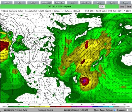
Latest GFS going all 2020. This is the week before Thanksgiving and not to be taken seriously at this point.
1604417295777.png
You know, yesterday I almost drew a map (the one with the models going all over the place and curving everywhere) showing the cone coming for Louisiana and I thought, "nah, that would just jinx us." And then we have this. :covri:
 
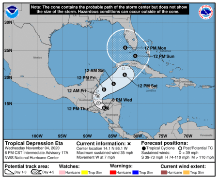
Eta weakening over central America, expected to emerge over the western Caribbean Sea later this week and move toward the eastern Gulf of Mexico and FL.

Discussion:
Eta made landfall along the eastern coast of Nicaragua and has continued to move slowly inland and is currently located over NW Nicaragua. While the overall cloud pattern with Eta remains well organized, the low level center is gradually weakening and spinning down and this process will continue.

Track:
Eta continues to move west along the south side of a mid level ridge to its north. This ridge will weaken over the next 24 hours and shift east allowing Eta to move toward the WNW and eventually the NW and N over portions of Honduras and Belize. An upper level trough will begin to develop over the Gulf of Mexico by this weekend and this will impart a NNE to NE steering motion across the western Caribbean Sea and carry Eta in the general direction of Cuba. By early next week, Eta will likely turn back to the N and even NW as the tropical system rounds the eastern and northeast side of the upper trough over the Gulf of Mexico. The track forecast is of fairly low confidence given the various steering factors at play and the likelihood that the low level vortex associated with Eta will dissipate over central America and some sort of new low level center will form over the western Caribbean Sea by Friday into Saturday.

Intensity:
Eta is weakening and this process will continue as the low level center interacts with the high mountains of central America. It is likely that the current low level vortex will dissipate in the next 24-36 hours and that the upper level organization of Eta will be what moves over the western Caribbean Sea by late Friday. A new low level center is expected to form under the upper level circulation over the western Caribbean Sea, but upper level conditions are not expected to be overly favorable for development with the nearby upper level trough over the Gulf of Mexico and dry air likely to the west of the circulation. In fact, what re-develops over the western Caribbean Sea could be more sub-tropical than purely tropical in nature.

Jeff Lindner
Director Hydrologic Operations Division/Meteorologist
Harris County Flood Control District
 
Looking at the GFS model, longer range, so it's gobblygook... But it comes off central America, hits cuba, goes near florida, passes west in the florida straits gives Key West a love tap, then back to cuba, then hits the Yucatan... what???

The Euro has a somewhat different solution... Hitting cuba, goes near southern florida, hits or glances key west, then goes to the central gulf, uncomfortably close to Louisiana, then darts back to the panhandle between Tallahassee and Panama city.

Models keep it weak though, but... they've all been doing that. So, I don't trust it.
 
Eta weakens to a tropical depression over central America…but will redevelop over the western Caribbean Sea.

Discussion:

Eta continues to weaken after having passed over the high mountainous terrain over central America in the last 24 hours. It is hard to find much evidence of any low level circulation on visible satellite images and it is very possible that the low level vortex of Eta has dissipated. With that said, the remains of the tropical system will be moving back over the warm waters of the western Caribbean Sea later today where re-development is likely and support by many of the global forecast models.

Track:
Eta has turned toward the NW and this motion at a slow rate of speed is likely through the next 24 hours before a trough of low pressure that will develop along the Louisiana coast digs southeast into the central Gulf of Mexico over the weekend. This trough will result in a NE motion of Eta toward the Cayman Islands and Cuba over the weekend. By early next week this trough will dig into the southeast Gulf of Mexico and Eta will turn sharply toward the NW and even west on the northeast or northern side of the Gulf upper level trough and an usually strong high pressure ridge for this time of year over the eastern US. This track will bring Eta toward the southern FL Keys and then into the southeast Gulf of Mexico by early next week. The multi-model consensus continues to struggle with the various steering patterns and changes in those patterns over the next 5 days and the various turns in direction and forward speed of the system. The forecast track in the 72-120 hour period is of lower than average confidence and changes are likely, but a threat to the FL Keys and southern FL remains in play.

Intensity:
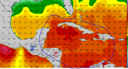
Eta will need to re-build its low level vortex and inner core and while water temperatures over the western Caribbean Sea are certainly warm, the upper level conditions may not be overly favorable mostly due to the upper level trough expected over the Gulf of Mexico with likely some degree of southwesterly shear over the tropical system. It is possible that Eta may eventually transition toward a sub-tropical system as it becomes increasingly entangled with the upper level trough over the Gulf of Mexico. For now NHC brings the system to a 65mph tropical storm over the FL straits early next week with some of the intensity guidance showing slightly stronger solutions that would be near hurricane intensity.

Jeff Lindner
Director Hydrologic Operations Division/Meteorologist
Harris County Flood Control District
 

Create an account or login to comment

You must be a member in order to leave a comment

Create account

Create an account on our community. It's easy!

Log in

Already have an account? Log in here.

Users who are viewing this thread

    Back
    Top Bottom