2024 Tropical Weather Thread (8 Viewers)

Lost power and cell around 9 last night. My phone has been in SOS mode until maybe 30 minutes ago. Still a little shaky but it’s at least something.
Guess I’ll wait for some sun and get the generator rolling. I’m sure power will come back 20 minutes later

Right on cue I lost service again trying to send that.
 
recently moved to Broadmoor area (right on Napoleon) and am very surprised how little impact we had
especially hearing how much Lakeview and Bywater got
we had minimal street flooding and only some small branches on ground
already got cars off neutral ground
sorry for everyone else's damage, but it feels like we dodged one
I've figured something out over the years through experience......unless you are in the eyewall of one of these beasts, you are generally gonna be fine. But if you are unlucky enough to hit an eyewall, good luck. Serious damage occurs there - especially if its a CAT3 or greater.
 
Your post made me think about this, but for the last few days, Rob Perillo, the Meteorologist at KATC TV-3 in Lafayette, kept going against the national forecasters by saying that the center of Francine would go east of where they had it tracking, which most of the national forecasters had going right up through Vermilion Bay and Lafayette.

Perhaps not his exact words, as this is from memory. However, paraphrased, "This is just my opinion, but I believe that landfall will be about 50 miles east of that track" (which was really close), and detailed why. He was also on point, covering the damage risks.

I don't watch the local weather much unless a big storm like this is looming, so this could be a one-off, however, I think the Weather Channel or some other National Weather Service might want to consider replacing one of their Chief Meteorologists/Forecasters with that guy.

The guy on Fox 8 did the same, and also everything @bclemms said.

Also having watched these storms for years, it was pretty clear it was going to move east. The models have improved a lot over the years and I don’t think AI has much to add here since it’s just going to aggregate data that already exists.
 
I agree with a lot of what you are saying but 2.5 days ago it was clear that anyone living from Lafayette to the MS gulf coast would see impacts.

This storm was a solid cat 1. The NHC called it a cat 2 but I havent seen anything close to 96mph sustained winds. Saw a 98 mph gust on land.

If you live in an area impacted by this storm, you live on one of the more hurricane prone places on earth and should be prepared June-November.

I think the highest wind gust the nola metro got was 71. This was a low end hurricane. Most people think they have been in a hurricane but the eyewall is an entirely different beast.

For days I’ve been saying I thought it would hit Morgan City or a bit East. Kept mentioning East motion. It came in a little stronger than I thought but only about 10mph. Even said Nola would gust 60-70. I also mentioned Cocodrie being the surge bullseye multiple times.

As for the flooding, that stalled motion added a few inches of rain and caused problems.
Yeah It had to have stalled . This caught even the meteorologists off too . They were also having issues finding the eye of the storm.
 
Anyone in Marrero area? Have an elderly aunt who lives alone. She's way too stubborn to go stay with someone else during storms. She's off of Barataria not to far from Lapalco.
She never answers her phone either.
I know where my hard head comes from.
 
Covington seemingly fine. We got the bulk of weather around 10 til 11:30. Some minor street flooding, I didn't see any trees down along hwy 21, 1085, I12 or 190.

Winds weren't all that bad maybe 30 sustained with a gust here and there of 50.

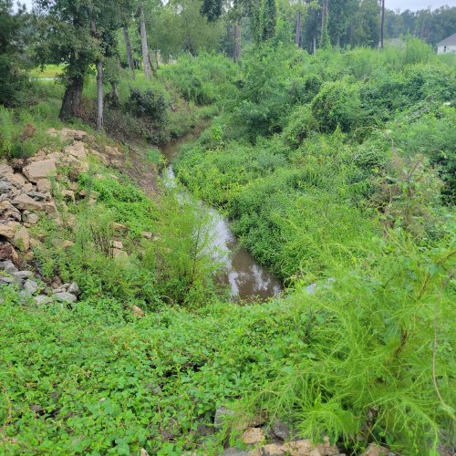
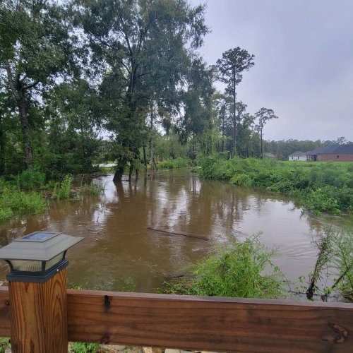
It's the water/rain. Only one main drainage avenue. Tchefunte. And when that backs up, so does everything else (feeder creeks, bayous etc)

How it started
How it's going
Photo taken from same spot ...11 am yesterday and 7am today.
 

Attachments

  • 20240911_073147.jpg
    20240911_073147.jpg
    2 MB · Views: 7
  • 20240912_073341.jpg
    20240912_073341.jpg
    1.2 MB · Views: 7
Covington seemingly fine. We got the bulk of weather around 10 til 11:30. Some minor street flooding, I didn't see any trees down along hwy 21, 1085, I12 or 190.

Winds weren't all that bad maybe 30 sustained with a gust here and there of 50.

It's the water/rain. Only one main drainage avenue. Tchefunte. And when that backs up, so does everything else (feeder creeks, bayous etc)

How it started
How it's going
Photo taken from same spot ...11 am yesterday and 7am today.
was thinking about that - tchefuncte was already pretty high going into yesterday
 
The guy on Fox 8 did the same, and also everything @bclemms said.

Also having watched these storms for years, it was pretty clear it was going to move east. The models have improved a lot over the years and I don’t think AI has much to add here since it’s just going to aggregate data that already exists.

Lee Zurch was really getting upset at around midnight with the whole flooding situation. Even brought Bruce Katz into the conversation ( thats the guy who called its eastern move ) about "did we get that much rain that the pumps couldnt handle???"

Bruce attempted to be pragmatic but just couldnt - said no. Its a major problem that these pumps dont work, S&WB refuses to answer calls/questions as to why, railing on the billions that poured in post Katrina AND WE STILL CANT GET WATER PUMPED OUT and no one knows why since NO/S&WB will simply not answer questions.
 
ill just add- the "threat stress" and subsequent "claims/restoration/clean up stress" is reaching a saturation point for many.

I know we live near sea level. I know we have antiquated drainage/sewer pipes. I know we have to pump out water. With the obvious issue of climate change and storms producing ( not only tropical systems ) massive amounts of rain, coupled with the mass development of virtually every single piece of land available for development, we continue to play catch up on this issue. We never seemingly have gotten ahead of it and yet again, dealing with water levels in areas that havent seen this type of water ever.

Im not a civil engineer or hydrologist, but i have to imagine there are some bright folks out there that can come up with something that will alleviate SOME of the water pressures we face in the GNO area.

right???
SWB has antiquated power requirements, and until that is fixed, they are playing wack-a-mole and things aren't going to get better. The only thing that will fix it is money, and no one wants to pay for it.

And the Katrina money built a brand new infrastructure to dump the water into the lake, but if you can't get the water TO those pumps, they don't do you any good.
 

Create an account or login to comment

You must be a member in order to leave a comment

Create account

Create an account on our community. It's easy!

Log in

Already have an account? Log in here.

Users who are viewing this thread

    Back
    Top Bottom