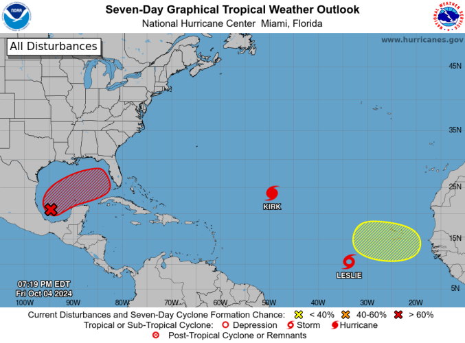
2024 Tropical Weather Thread (14 Viewers)

Although I will say that lots of people talked smack about people should not live in flood zones and areas prone to natural disasters post Katrina. It took hurricanes and blizzards in New York for people to start realizing that natural disasters and floods can happen most places.
My husband and I bring that up a lot. "People should not live in a bowl". "Hmmm, hope you don't live on the side of a hill in an earthquake zone, Karen."
 
NC IS a "concurrent causation" state.

Now it wont help flood victims, but might help folks with landslide


My parents have a place in Boone and they didn’t have damage but the next neighborhood where their friends live did.

He told me that “[Their] underwriters have advised they will cover their policyholders under the backed up water vs rising water clauses. Hopefully some of the others will follow suit.”

Do you know about backed up water and rising water clauses?
 
My husband and I bring that up a lot. "People should not live in a bowl". "Hmmm, hope you don't live on the side of a hill in an earthquake zone, Karen."
My hope with this storm is that there is no longer any room to make that ‘well why do you live in a hurricane zone/tornado alley/ earthquake area/drought/blizzard, et al
Literally no one is immune to weather
 
My parents have a place in Boone and they didn’t have damage but the next neighborhood where their friends live did.

He told me that “[Their] underwriters have advised they will cover their policyholders under the backed up water vs rising water clauses. Hopefully some of the others will follow suit.”

Do you know about backed up water and rising water clauses?

Technically "water backup" is for claims arising out of water in homes from backed up sewer lines ( or some other form of backflow).

I would imagine the "rising water" is an exclusion since rising water is generally considered flood.

So sounds to me as if the carrier will allow them to file claim for water back up.

Now the caveat is (without seeing policy terms , coverage and conditions) is there is usually a "sublimit" (or cap) on loss. Anywhere from 10k to 25k specific to water back up.
 
Still showing a TS crossing the peninsula and heading out to the east, yes?
GFS, yes. euro shows large cat 2. Ship guidance is split between moderate TS and major hurricane. Icon has a cat 1. Hurricane models are all over. Euro ensemble shows a consistent cat 1/2 signal. If timing is right it will hit during astronomical peak tides. Right now the GFS is the outlier.

Euro feels really locked in on this one run after run. If it is right its going to crush the remaining part of Florida’s West coast with storm surge.

I know how terrible the Carolinas are but people aren’t comprehending how bad Florida was hit from Helene. I bet more homes were badly damaged/destroyed in Florida. Carolinas infrastructure and humanitarian side is far worse but Helene really worked Florida to the point it would be a huge story still if not for the flooding.

I just hope the season is done after this but somehow I doubt it.
 
Last edited:
Just finished Eye of the Storm docuseries on Prime.
6 part series on 6 major weather events...Iowa Derecho, Tornados in Texas and Kansas, Ida, Buffalo blizzard, Lahaina wildfire.

The one thing that sticks out...ALL OF these events have happened in just last 4 years.

I don't know if we are simply at the peak of a cycle of hyper weather or if in fact it's climate change...I tend to think it's a bit of both, but there is NO denying we are in a very tumultuous period of weather events that seemingly are getting worse
Jonathan and I had video in 5/6 episodes. I was t there for tge Iowa derecho. The blizzard in Buffalo was one of the craziest storms i have covered.

What they didn’t hit yet was Rolling Fork tornado, Ian, Helene, Beryl, California Blizzard, Dixie Fire, Superior Fire, hurricane Kay in California, western KY floods, Mayfield tornado, Greenfield tornado, etc.

The producer of the show said its crazy they are probably going to sell 3 seasons on current disasters while new ones are happening faster than they can catch up.

So they plan on additional episodes?

It's well produced. Some of the video is very compelling.

The blizzard dash cam footage of the pile ups...unbelievable.

I'm looking forward to the next ones. Fascinated with weather.

Well done B.
 
****DO NOT TAKE THESE IMAGES LITERALLY****


The GFS finally got in line with the other models and it's pissed. Now I hope the Euro and Icon is right. If the current GFS or most hurricane models verify it would be a Katrina level event in 4 days in Tampa at a time our countries ability to respond is stretched extremely thin. I'm not saying this will happen but good god, the odds are starting to get close to a coin flip. This could obliterate insurance, could drastically impact the election, impact markets, etc. This is just 1-2 runs and should not be taken literally but I'm really concerned about how unprepared people will be for what this would do during astronomical high tides. The current GFS is basically showing a 16-18' storm surge into Tampa Bay during. The EURO has been extremely consistent and although it's likely to be underdone, I do think that it is probably closer to right than the below runs. However, this is a signal that can't be ignored. 1-2 more model runs like this and every panic alarm in Florida will be going off.
1728129420959.png


1728129534185.png

1728130007265.png

1728130123909.png
 

Attachments

  • 1728129468131.png
    1728129468131.png
    795.2 KB · Views: 4
Last edited:
This is the Euro and Icon models which are now the outlier and best case scenario. Even this would be extremely problematic. The angle of this storm plus the size of the storm and during astronomically high tides are big problems.
1728130669317.png

1728130762762.png
 

Create an account or login to comment

You must be a member in order to leave a comment

Create account

Create an account on our community. It's easy!

Log in

Already have an account? Log in here.

Users who are viewing this thread

    Back
    Top Bottom