brandon8283
Probably a drive-by
- Joined
- Jul 11, 2009
- Messages
- 10,028
- Reaction score
- 13,831
- Age
- 41
Offline
Follow along with the video below to see how to install our site as a web app on your home screen.
Note: This feature may not be available in some browsers.
Trust me, I know. I hate me too right now.You’re approaching Jim Cantore levels of unwelcomeness.
My hope with this storm is that there is no longer any room to make that ‘well why do you live in a hurricane zone/tornado alley/ earthquake area/drought/blizzard, et al
Literally no one is immune to weather
It wont.
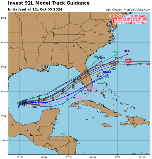
****DO NOT TAKE THESE IMAGES LITERALLY****
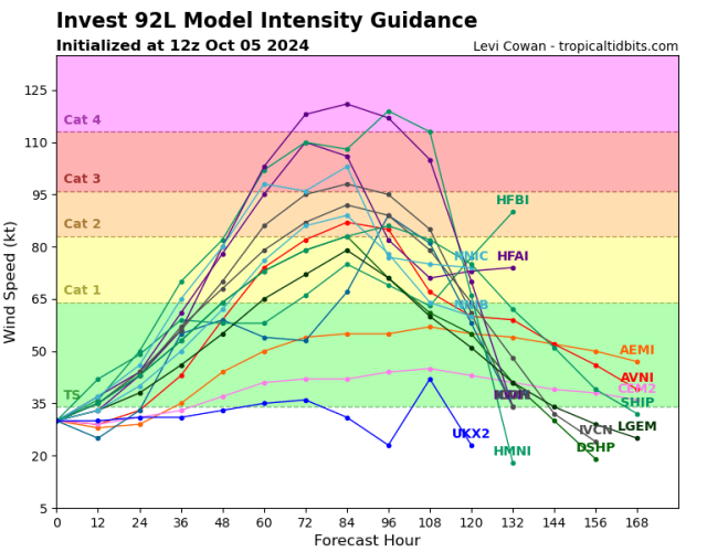
The GFS finally got in line with the other models and it's pissed. Now I hope the Euro and Icon is right. If the current GFS or most hurricane models verify it would be a Katrina level event in 4 days in Tampa at a time our countries ability to respond is stretched extremely thin. I'm not saying this will happen but good god, the odds are starting to get close to a coin flip. This could obliterate insurance, could drastically impact the election, impact markets, etc. This is just 1-2 runs and should not be taken literally but I'm really concerned about how unprepared people will be for what this would do during astronomical high tides. The current GFS is basically showing a 16-18' storm surge into Tampa Bay during. The EURO has been extremely consistent and although it's likely to be underdone, I do think that it is probably closer to right than the below runs. However, this is a signal that can't be ignored. 1-2 more model runs like this and every panic alarm in Florida will be going off.

This is 4 days out. This is a very real possibility. I would say 30% chance of something really bad takes place at this point. If the next two runs the models look locked in and Euro starts to push in line with the other models then it'll be more likely than not.How often do these nightmare scenarios play out (as shown in your images) this far in advance? Is this like a 1 in 10 or a 50/50 chance? Or worse?!?!?


Tampa has dodged a lot of bullets. That luck will eventually run out.This is 4 days out. This is a very real possibility. I would say 30% chance of something really bad takes place at this point. If the next two runs the models look locked in and Euro starts to push in line with the other models then it'll be more likely than not.
The first is intensity models. With the hurricane models (not shown) being to the high side of intensity guidance the official forecast if the models are consistent would be about 110-115mph hurricane just offshore of Bradenton. The second image is the spaghetti models showing the southern solution is now the outlier. The current satellite images of this thing looks to already be outperforming all guidance. It's too early to tell if this is a head fake or a trend. If it becomes a trend expect intensity guidance to continue to inch higher. Most models have a weakening trend at landfall but the surge wont care about the wind speed.
It takes at least 72 hours to evacuate the Tampa area and the GFS/hurricane models solution makes evacuation of damn near all of Tampa a necessity due to unsurvivable storm surge. Somebody is about to have to make some really difficult decisions without a high level of certainty.
That may be difficult. The backside surge on the East coast could be tricky on this one. I think Jacksonville to Savannah may be the biggest issue but it'll depend on track and strengthDang - doesn’t look good. My good friend lives in Sarasota, and he said yeah they’re already starting to consider options.
We’re supposed to be flying down from Charleston into Orlando on Thursday evening, heading over to Canaveral for a cruise departure on Friday.
That may be difficult. The backside surge on the East coast could be tricky on this one. I think Jacksonville to Savannah may be the biggest issue but it'll depend on track and strength
I got ya. If you haven't booked a room, I would do it now. From a wind standpoint, it'll be mostly trees and power outages type of stuff on the east coast. Not sure what they do with cruise ships in this situation.Thanks - I welcome any additional comments you have as this thing progresses. We’re probably gonna be a game time decision on this.
Nope not one bit.
BUT, what it will do is cause people to reassess risks. The VAST majority of those in NC have no flood insurance. They’ll either have to have a federal level bailout, pass on rebuilding, or go bankrupt, etc., etc…
One thing that I think can come out of this is a new requirement for everyone to get national flood insurance.