2024 Tropical Weather Thread (6 Viewers)

I've been interested in this strategy for a while. The idea of solar with batteries in lieu of the whole home generator sounds great. And we want to go EV, or at least Plug-In hybrid with a car soon, as well. I know it's a lot more upfront, but it seems like there is a glide path towards payback.

Did you piece together a system of some sort, or did you go integrated, like a Tesla solar/wall system? Whichever you chose, how do you like it and do you have any regrets? I don't care to enrich Musk, but haven't come across any comparable systems yet. Any suggestions?
Got the solar panels and then one Tesla wall. The solar panels aren't Tesla. Also the EV I'm looking for isn't out yet or reasonably priced yet but the next gen should. Those will basically have the equivalent of 8-10 Tesla walls and be capable of running the house for a few days by itself vs the Tesla wall that will basically give 8-12 hours of minimal backup. I've been extremely happy with it. Wish MS gave a higher percentage of energy buy back. The rates we get in MS/LA don't really make additional power generation worthwhile so storage is important.
 
well if its any consolation, i pass out when i give blood. ( even for routine wellness )

every time. Now to the point that when i have to give blood, i get so worked up that its inevitable.

so i get the reclining chair for bloodwork and low dose valium for any procedure that requires me to be stuck with needle lol.
I feel for you, luckily needles or blood don't bother me, it's the pain from whatever they shove in that gets me. I got to watch on the xray this morning as the Dr. searched around the joint in my back for the right spot, that was ok. Then it got real when he pushed the concoction in.
Sorry, way off topic.
In the weather news, I hope I am fit enough to evacuate should the need arise.
 
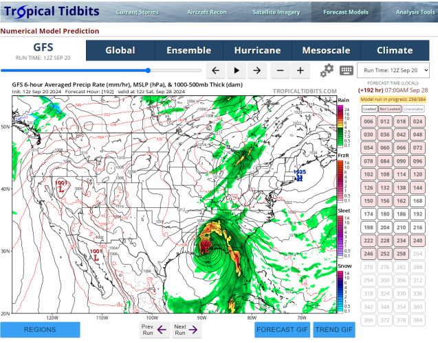
today's GFS run not looking as nice as yesterday's

yeah from Gulf Shores to Destin -

im sure it will continue to waffle each run until something actually develops. Certainly worth keeping track of and making sure all your insurance is up to date ( because once a named storm in GoM, most carriers cease any sort of new or endorsement ( policy changes ) ability )
 
No Me Gusta

1726851298955.png
Pressure of 977 is a borderline Cat1/Cat2 so this wouldn't be a doomsday scenario. Certainly no fun with power outages, downed trees, tornado threat, and a rain event - especially if moving slowly - but not a wipe off the map situation. It would be a Florence-ish type of storm, if this model came to fruition. Still, until there's actually something to track, the models are all over the place.
 
Pressure of 977 is a borderline Cat1/Cat2 so this wouldn't be a doomsday scenario. Certainly no fun with power outages, downed trees, tornado threat, and a rain event - especially if moving slowly - but not a wipe off the map situation. It would be a Florence-ish type of storm, if this model came to fruition. Still, until there's actually something to track, the models are all over the place.

Yeah I'm not panicking and frankly if it did hit there it might not be terrible for New Orleans and Metairie since we would be on the western side which would theoretically be weaker with less rain, but it would be major issues for Biloxi/Gulf Port and maybe Mobile, Gulf Shores and Pensacola. But if that was the track a wobble at the end could make all the difference as usual.
 
Last edited:
Pressure of 977 is a borderline Cat1/Cat2 so this wouldn't be a doomsday scenario. Certainly no fun with power outages, downed trees, tornado threat, and a rain event - especially if moving slowly - but not a wipe off the map situation. It would be a Florence-ish type of storm, if this model came to fruition. Still, until there's actually something to track, the models are all over the place.
I hear you, but hasn't rapid & unexpected intensification been a hallmark of many of the recent storms?
 
So I am admittedly lost here, but I'm sure this is a cake explanation for most of ya'll

Is the intent of these models to indicate that conditions would be favorable to these forecasts if a storm would form? Or is it actually forecasting this will form? And how far out is it projecting, is it the second "valid at" timestamp?
The intent of the models is both.

It is to represent the upper air conditions that make a storm favorable to develop. Then when that storm develops the atmospheric conditions to allow strengthening of the storm and ultimately a strength and location.

Each model is not meant to be taken literally. They were developed as a sweet of models that give different forecast scenarios based on what they think will happen. The earlier that model starts getting stuff wrong the bigger the spread becomes with time. So this is why forecasters look at 10-12 models and ensembles. Then most look for a mean average to make a forecast that is more probable.

When you start looking 10 days out.
1. The storm hasn't formed yet
2. The location of storm forming is thousands of miles away.
3. The steering currents such as a trough is usually just developing off the coast of China.

The models are trying to predict what the wind speed and direction will be at 10 different heights across 190M miles of area, the water temps at different depths of oceans with active current shaping those water temps, where the storm will likely develop and how that storm will move based on the winds, how much shear will be present allowing the storm to intensify, how the moisture channels will set up to feed the storm and how big that storm may be.

If they get one of those wrongs it has a cascading effect. For each variable that is wrong, it magnifies the error over time. Weather models are some of the most complex set of equations on the planet run by some of the world's largest super computers and still a long way away from perfection.
 
tropics2pm0920.jpg


That is the one that I got


Create an account or login to comment

You must be a member in order to leave a comment

Create account

Create an account on our community. It's easy!

Log in

Already have an account? Log in here.

Users who are viewing this thread

    Back
    Top Bottom