2024 Tropical Weather Thread (2 Viewers)

I’ve been to Chimney Rock a few times, I know I went once in the 80s as a child. Western NC is dotted with those places, seemingly frozen in time. This storm has literally erased bits of American culture.
When I was at UNCG this area is where I did most of my camping
Boone is a frikkin idyll
These pics/vids are hard to fathom
 
Is that clingmans dome in the background? I remember going there on a family vacation when i was a child. It's the highest point in the smokey mountains and you can view 7 states from the peak.

I think Mt. Mitchell is highest point but Clingmans is almost as high and because it’s basically on the TN border you can see all the states (Mitchell is NE of Asheville - Clingmans might actually be the highest observation point that you can get to without being a mountain climber). Chimney Rock is SE of Asheville and has a couple of mountains much closer to it, probably one of those in the photo.
 
I’ve been to Chimney Rock a few times, I know I went once in the 80s as a child. Western NC is dotted with those places, seemingly frozen in time. This storm has literally erased bits of American culture.

As I mentioned, my brother has a cabin on Black Mountain about 20 minutes from Chimney Rock/Lake Lure. My entire family went there a few years ago and we visited Lake Lure and Chimney Rock. Chimney Rock reminded me of how Cherokee was when I went there with my family as a kid in the early 80s. Really horrible seeing all those places destroyed and then realizing that my brother has a lot of friends down the mountain that are likely flooded out.
 
Just lost power - it’s nasty as hell here. Storm definitely tracked well east of the NHC track and more in line with the model. We’ve had multiple tornado warnings.

I imagine this was harrowing and traumatic for people in south GA.


Let us know how you’re doing when you can.
The eye of the storm passed right over us (Valdosta area) but we made out ok. Valdosta is messed up but could’ve been much worse. We’re living on a generator but feeling blessed.
 
The eye of the storm passed right over us (Valdosta area) but we made out ok. Valdosta is messed up but could’ve been much worse. We’re living on a generator but feeling blessed.

Relief to hear from you - so glad y’all fared okay!
 
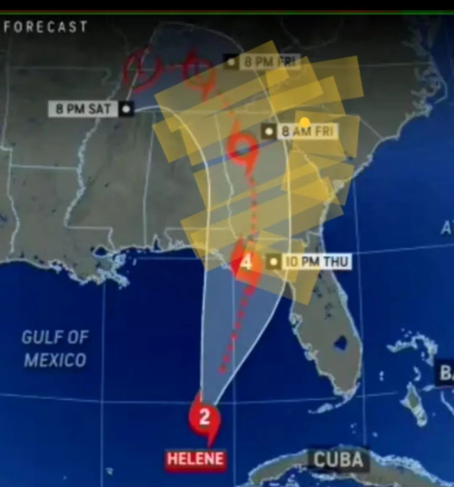
This thing contours to look east of the track, which remains unchanged. It’s gonna have to do some actual bending back to the west before landfall to make the NHC track. That was never projected.

There continues to be this divergence between the NHC track and the models. The NHC track is a good turn to the north and northwest going past Atlanta while both of the euro and the GFS have it more gradual and going past western South Carolina. I’m watching weather channel and their graphics are alternating between the NHC track and then later they show the model track and you’re sitting there going they’re quite different. Big difference for where I am. And my parents in Boone NC

This first post was about 10 hours before landfall and the second was about 6 hours before. NHC never adjusted the track - which I don’t think helped the NC folks as much as it could have.
Actual track vs NHC:

1727542043656.png
 
This first post was about 10 hours before landfall and the second was about 6 hours before. NHC never adjusted the track - which I don’t think helped the NC folks as much as it could have.
Actual track vs NHC:

1727542043656.png

NHC did the same thing with Francine. The models and a few local guys kept saying it was going to track East of the NHC track and it was obvious that is what it was doing even up to the point that the broken up eye wall went through Jefferson and Orleans Parish, but the NHC never changed their track.

But, this should be a lesson to all that being on the edge of the cone of uncertainty, or even a bit outside of it, doesn't mean you are safe. Little wobbles make all the difference for some.

Yeah, that’s true, and I’m not sure how much of an impact it would’ve made to have that track shifted. I don’t know if people in that area really anticipated the degree to which swift water would be everywhere, threatening dams, etc. And I don’t think changing the track hours ahead of it would have made much difference.
 
People just driving along like there is nothing to see here?


A few hours ago I was driving down 81s in TN and about e
30 miles north of I40 there was a warning sign that 40E was closed at exit 35 (?) due to flooding. That might be very well what the sign was warning about.

thankfully I didn't run into any issues from storm damage in TN or NE Georgia. A few highway signs knocked down but that was it. I am now in a hotel just north of Birmingham so I won't see anything tomorrow when I finish my trip to West Monroe tomorrow. Leaving early enough to get there for the Saints game!
 

Create an account or login to comment

You must be a member in order to leave a comment

Create account

Create an account on our community. It's easy!

Log in

Already have an account? Log in here.

Users who are viewing this thread

    Back
    Top Bottom